French Guiana – Climate: Guyaclimat forecasts for French Guiana to 2100

Guyaclimat

A scientific program to anticipate the future climate

Guyaclimat is a benchmark study that analyzes the climatic transformations expected in French Guiana up to 2100. Carried out by Météo-France and the Bureau de recherches géologiques et minières (BRGM), this program is based on detailed regional projections to be released in 2022. The results provide a basis for action by local authorities, developers and economic players.

A response to targeted local demand

Specific needs in the face of the limitations of global models

For a number of years, Guyanese decision-makers have been calling for projections tailored to the realities of the territory. Although the IPCC’s global climate models are accurate on a planetary scale, they are not sufficient for effective planning on a local scale. Guyaclimat meets this need by providing analyses of five parameters: temperature, precipitation, wind, waves and sea level.

Multi-stakeholder financing

This project is supported by the Direction Générale des Territoires et de la Mer (DGTM), the Agence Française de Développement (AFD), the Agence de la Transition Ecologique (ADEME), the Office de l’Eau de Guyane, Météo-France and BRGM.

Guyaclimat
©Dans les forêts de Guyane

An adapted scientific methodology

Local data and advanced modeling

Guyaclimat teams combined field surveys, local observation data and global climate simulations from the sixth CMIP6 exercise. Downscaling of the global models was carried out with quantile-quantile bias correction, using the long series of observations from Guyana’s weather stations.

Climate scenarios

For atmospheric variables, two socio-economic scenarios were used: SSP2-4.5 (moderate emissions) and SSP5-8.5 (high emissions). For sea-level rise, the study uses the RCP2.6, RCP4.5 and RCP8.5 scenarios, as well as a scenario high-end for extreme cases.

Guyaclimat
©Météo-France Guyane

Temperatures: a sustained and marked rise

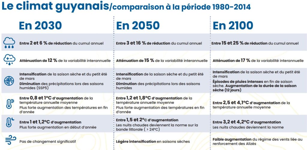
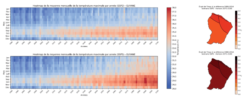
According to Guyaclimat, warming between now and 2100 will be between +1.5°C and +4°C, depending on emissions trajectories. Maximum temperatures could rise by +2.5 to +4.1°C, especially between August and November. In the Cayenne-Matoury area, afternoons would regularly exceed 34°C in the SSP5-8.5 scenario.

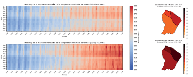
Minimums are expected to rise from +3.2 to +4.2°C, leading to more frequent hot nights throughout the year, with direct implications for public health and energy consumption.

Guyaclimat
Changes in maximum temperatures in French Guiana from 1980 to 2100 for both scenarios ©Météo-France Guyane
Guyaclimat
Changes in minimum temperatures in French Guiana ©Météo-France Guyane

Precipitation: more intense dry seasons

Guyaclimat simulations indicate an annual fall in precipitation of between -3% and -26%, depending on the scenario. This decrease would be particularly marked during the “little summer of March” and the long dry season. In September, the drop could reach -75% in some areas.

These trends would accentuate water stress and put pressure on forest ecosystems, whose equilibrium depends on regular water supplies.

Guyaclimat
Rainfall trends in French Guiana ©Météo-France Guyane

Sea level: the growing risk of chronic submersions

Guyaclimat forecasts a mean sea-level rise of +0.84 m by 2100 in the RCP8.5 scenario, with an uncertainty of between 0.59 and 1.17 m. This rise favors chronic submersions: temporary flooding occurring during high tides, even in calm weather.

The maps produced by the study identify vulnerable areas, in particular Cayenne, Kourou and Mana, and provide essential tools for guiding coastal development policies.

The Amazon rainforest, an ecological pillar under pressure

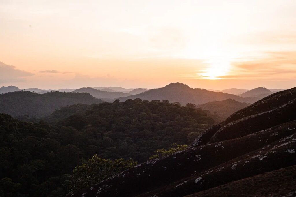
Covering around 97% of the country, Guiana’s forests are a major carbon sink. Guyaclimat points out that rising temperatures can reduce this capacity: in hot weather, trees close their stomata, slowing down photosynthesis and growth, thus limiting the absorption of carbon dioxide.

Guyaclimat
©Dans les forêts de Guyane
Guyaclimat
©Dans les forêts de Guyane
Guyaclimat
©Dans les forêts de Guyane
Guyaclimat
©Dans les forêts de Guyane
Guyaclimat
©Dans les forêts de Guyane
Guyaclimat
©Dans les forêts de Guyane

A strategic tool for adaptation

Guyaclimat is not limited to scientific analysis: it provides public and private players with a basis for decision-making. Projections can be integrated into development, resource management and risk prevention plans. The water, agriculture and energy sectors thus have reliable data with which to adapt their strategies.

Guyaclimat’s forecasts for 2100 highlight profound transformations: marked warming, reduced rainfall, rising sea levels and increased pressure on biodiversity. These findings call for swift, coordinated, science-based action to preserve the region and its inhabitants in the face of the century’s climatic challenges.

Leave a Reply

Your email address will not be published. Required fields are marked *

More articles from RK

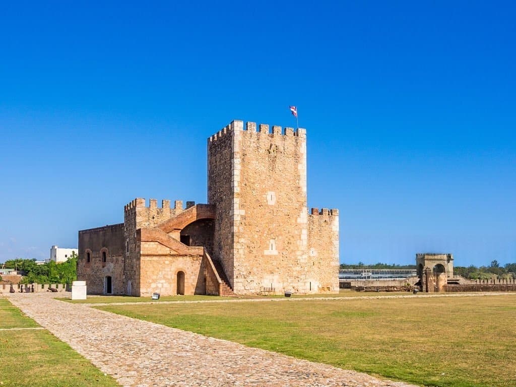
View of Fortaleza Ozama and its Torre del Homenaje tower, in Santo Domingo
HISTORY & HERITAGE
Tolotra

Fortaleza Ozama, the 1502 fortress where a nation was born

In Santo Domingo, on the banks of the Ozama River, the Fortaleza Ozama has weathered more than five centuries of Dominican history without ever falling into the hands of an attacker. It held the father of Dominican independence captive, served as a political prison under the Trujillo dictatorship, and withstood tank fire during the 1965 civil war. Now a UNESCO World Heritage Site, the oldest European-built fortress still standing in the Americas continues to preserve, almost intact, the memory of a nation. An arrival in chains, August 27, 1844 On August 22, 1844, Juan Pablo Duarte was arrested in Puerto Plata. Five days later, on August 27, he entered the Fortaleza Ozama in Santo Domingo. The government led by Pedro Santana had just declared him a traitor to the nation. Duarte, who had planned and led the young Dominican Republic to independence, was imprisoned in the dungeons of the Torre
Read More »
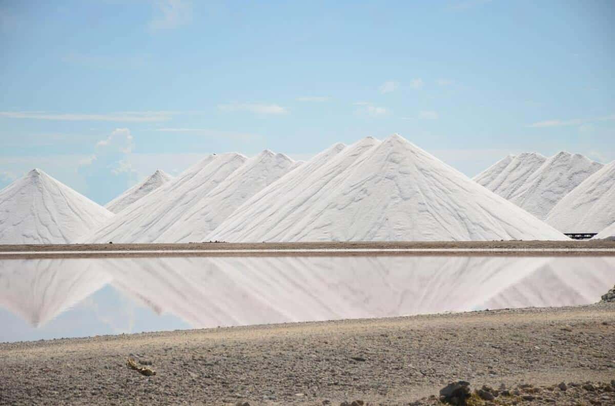
Bonaire salt marshes: pink ponds and white salt mountains in the south of the island
HISTORY & HERITAGE
Tolotra

Bonaire: 3,700 hectares of salt marshes conceal a history of slavery

At the southern tip of Bonaire, a Dutch-speaking island in the Caribbean, the salt marshes stretch out in pink and white basins across nearly 3,700 hectares—thirteen percent of the island’s total area. This postcard view, photographed every year by thousands of visitors from the coastal road, hides a history dating back more than five centuries, the story of salt that shaped Bonaire’s economy and, for two hundred years, the lives of hundreds of enslaved people. Along EEG Boulevard, which runs along the southern coast of Bonaire, mountains of white salt come into view kilometers before you reach them. Each contains about 10,000 metric tons of salt that is 99.6% pure, piled nearly 15 meters high, with up to 200,000 metric tons stored at any given time. Their whiteness, so intense that you need to keep sunglasses handy, stands in stark contrast to the pink of the neighboring pools. The salt
Read More »
Journées européennes du patrimoine 2026
EVENT MANAGEMENT
Tolotra

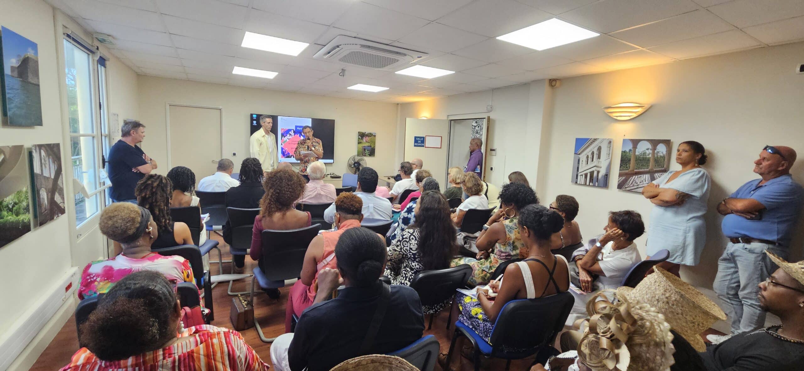
European Heritage Days 2026: Martinique Opens Its Archives.

On September 15, at 5 p.m., the conference room of Martinique’s Cultural Affairs Department is already packed. Journalists, cultural leaders, organizations, artists, and heritage professionals have gathered to find out what the 43rd edition has in store. With just four days to go before the 2026 European Heritage Days , scheduled for September 19 and 20, this press conference already feels like a journey across Martinique—from its Creole huts to its lighthouses, from Saint-Pierre to the monuments we sometimes pass by without really noticing them. European Heritage Days 2026: A Lively Conference Johan-Hilel Hamel, Martinique’s director of cultural affairs, opened the meeting without putting on airs. He even warned that the evening would not be a long monologue. The conversation quickly began to flow. A representative from Les Trois-Îlets speaks, followed by Xavier Nicolas from the Directorate of the Sea, Philippe Villard from the Heritage Foundation, Florence Le Gal from
Read More »

conTACT RK

we'd love to have your feedback on your experience so far

Join The List

Join our Richès Karayib community!  Sign up for our newsletter.

Want To Maximize Your Business Presence On Riches Karayib?

Complete the form to start the application