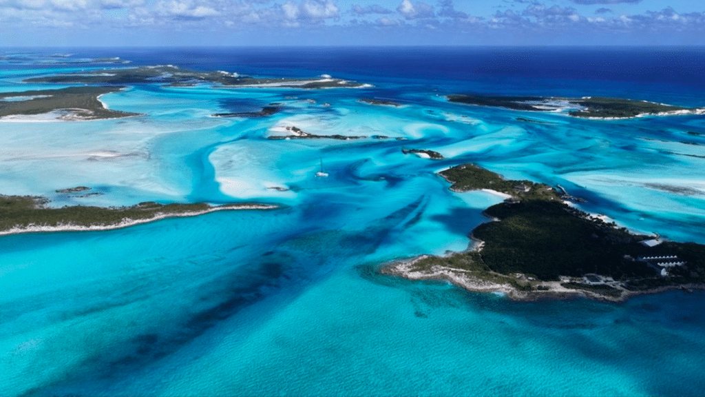
In the Bahamas archipelago, Exuma occupies a special place. This territory is not a single island, but a long chain of islets and cays stretching over 200 kilometers into the Caribbean Sea. For travelers, it represents a strong image of the Caribbean: shallow waters, sandbanks, small scattered islands and a constant relationship with the ocean.
The Exuma archipelago is made up of more than 360 islands and cays. The largest is Great Exuma, home to the main town of George Town. Great Exuma is linked by a bridge to Little Exuma, the second largest island in the district. This territorial configuration gives the whole area a clear organization: a few inhabited areas, surrounded by a multitude of largely unspoilt islets.
An area built around the sea
In Exuma, the sea isn’t just a landscape: it structures the whole of local life. The locals have historically made their living from fishing, sailing and ocean-related activities. The Bahamas’ shallow waters create vast turquoise lagoons, characteristic of the archipelago. The geography of the islands is relatively flat, composed of sand, limestone and low vegetation dominated by palms and coastal shrubs. This morphology allows the formation of numerous natural beaches and sandbanks visible at low tide.
For visitors, this configuration favors maritime activities: sailing between islets, coral reef observation and exploration of secluded coves.
An archipelago known for its scattered islets
One of the island’s most striking features is its scattered islets. The chain of islets forms a maritime corridor punctuated by uninhabited cays, small marinas and coastal villages. This geography has made the island particularly popular with sailors and travelers wishing to explore the Caribbean by sea. Some islands have become famous for their landscapes or natural features. These include Big Major Cay often called Pig Beach, attracts the attention of visitors for the presence of a colony of pigs living on the island. This uninhabited site has become a well-known tourist attraction in the archipelago.
The origin of these animals remains uncertain. There are several accounts of sailors who left the pigs on the island, or of an ancient shipwreck. Whatever the explanation, their presence today contributes to the archipelago’s notoriety.
An important marine protected area
It is also renowned for its environmental protection efforts. The archipelago is home to the Exuma Cays Land and Sea Park, created in 1958. The park covers a vast marine and terrestrial area designed to preserve coral reefs, mangroves and local biodiversity. The park is one of the first marine reserves of its kind in the world. Fishing is prohibited to protect ecosystems and fish populations. This conservation policy contributes to maintaining a relatively intact marine environment and supporting local species.
The park’s waters are home to sea turtles, conch, groupers and various species of seabirds that nest on isolated cays.


A history linked to the colonization of the Bahamas
The island’s history dates back to the end of the XVIIIᵉ century. After the American War of Independence, British Loyalist settlers moved to the islands to develop plantations, particularly of cotton. George Town, today the district’s main urban center, was founded at this time and bears the name of King George III. Over time, the agricultural economy declined and maritime activities took on greater importance. Today, the economy is based mainly on tourism, shipping and related services.
A region focused on nautical tourism
Exuma’s geographical configuration attracts many visitors interested in sailing, diving and coral reef exploration. Marinas and small ports serve as departure points for more isolated cays. Sea excursions allow visitors to visit several islands in a single day, a practice often referred to as “island hopping”. This approach fits in well with the geography of the territory, which is best discovered by sea rather than by road.
An emblematic Bahamas destination
For travelers, Exuma offers a very legible island experience: a large main island, Great Exuma, surrounded by a multitude of cays accessible by boat. This configuration alternates between inhabited villages and largely unspoilt seascapes. In this way, Exuma illustrates a Caribbean turned towards the ocean, where the archipelago and the sea remain the structuring elements of the territory.
Exuma is a district of the Bahamas located in the central part of the archipelago, southeast of Nassau. The territory consists of a long chain of islands and cays, stretching some 200 kilometers into the tropical Atlantic Ocean. The main inhabited islands are Great Exuma and Little Exuma linked by a bridge near the main town, George Town. The rest of the archipelago comprises hundreds of small, often uninhabited islands, accessible mainly by boat.
Exuma is particularly renowned for the clarity of its turquoise waters and the presence of numerous islets surrounded by shallow lagoons. The archipelago also attracts attention for its Pig Beach a small island known for its swimming pigs, now one of the Bahamas’ most photographed attractions. Beyond this curiosity, Exuma is also appreciated for its coral reefs, natural beaches and sandbars that appear at low tide.
The Exuma Cays Land and Sea Park is a nature reserve created in 1958 to protect the archipelago’s marine and terrestrial ecosystems. The park covers several dozen kilometers of islands and protected waters. Fishing is prohibited to preserve the coral reefs and marine biodiversity. Today, the park is one of the oldest examples of marine protection in the Bahamas, attracting visitors interested in sailing, diving and marine wildlife observation.