
Jamaica. Five months after Hurricane Melissa, the island is sending out a strong signal to the entire Caribbean: the country passed the one million visitor mark in the first quarter and has announced US$956 million in foreign currency earnings. For tourism authorities, this result confirms the speed of the recovery. For industry observers, above all, it shows that a destination hit by a climatic shock can quickly regain its place in the international travel circuit when confidence remains high.
A striking figure, which must be clearly understood
The million mark is impressive, but it needs to be read with care. In Jamaica, the category of visitor arrivals covers more than just tourists staying in hotels. National statistics distinguish between stay-over visitors, cruise passengers and other profiles included in overall arrivals. This nuance is important, as it enables us to correctly measure the scope of the announcement: the country has indeed returned to a high level of visitor arrivals, without this automatically meaning a million holidaymakers staying on site for several nights.
The first data available for 2026 show that the recovery has built up rapidly, but without erasing the consequences of Melissa all at once. In the first two months of the year, stayover arrivals were still below those of the previous year, as were cruise arrivals. The million mark passed in the first quarter is therefore a sign of a solid recovery, in a context that was still fragile just a few weeks earlier.

A recovery also driven by confidence
In island territories, tourism depends on infrastructure, of course, but also on external perception. After a hurricane, travellers want to know that airports are working, roads are passable, hotels are back in business and, above all, that their stay can be enjoyed in good conditions. This is where Jamaica has clearly succeeded in reassuring travellers. The authorities insisted on a central point: international confidence in the country’s ability to recover and maintain a high level of hospitality.
This confidence has been nurtured by another often underestimated player: the diaspora. At a meeting in Washington, Jamaican officials reminded us just how much the country’s communities abroad play a concrete role in its image. Even before making a reservation, future travelers listen to what their relatives, colleagues and friends have to say. When a diaspora speaks confidently about its island, corrects misinformation and encourages visitors to return, it plays a direct part in the recovery.


Market diversification begins to take its toll
Another element worthy of attention is the growth of markets that still occupy a more modest position than North America, but whose rise may reinforce the sector’s stability. Director of Tourism Donovan White reports a 25% year-to-date increase in the Latin American market and a 7% rise from Asia. These developments show that Jamaica is also making progress in the field of diversification, an important issue in limiting dependence on a few traditional emitting basins.
This movement takes on particular importance after a natural disaster. When a territory depends on a limited number of markets, the slightest slowdown can have a serious impact on revenues. Conversely, a broader customer base can cushion shocks and enable business to pick up more quickly. In Jamaica’s case, this gradual opening-up to other parts of the world complements the return of regular visitors.
Beyond the hotels, an entire economy is catching its breath
For Jamaica, this tourism rebound goes far beyond being a good indicator of visitor numbers. On the island, tourism supports an entire chain of activities: transport, catering, agriculture, crafts, services, culture and local commerce. When arrivals return, so does the income that flows back into areas that are sometimes far removed from the major seaside resorts. This is what gives this first quarter an economic and social significance that goes far beyond a simple assessment of the season.
The $956 million announced also serves as a reminder of the importance of foreign currency in the equilibrium of an island economy. In a country exposed to the vagaries of the weather, preserving this capacity to rapidly generate external revenue is becoming a central issue. The result put forward by the authorities does not resolve all the weaknesses revealed by Melissa, but it clearly indicates that the tourism machine has picked up speed again.


What Jamaica is showing the region today
Jamaica offers a picture of resilience that is of interest throughout the Caribbean. The country is demonstrating that rapid recovery relies on several levers at once: rehabilitated infrastructure, credible communication, a mobilized diasporic network and a continued presence on international markets. This million mark does not close the chapter opened by Melissa. Rather, it marks an important milestone: one in which a territory regains the initiative, reassures its visitors and puts an essential part of its economy back into motion.
Because Jamaican statistics use a broad category of visitor arrivals. It encompasses several types of visitation, with a distinction between stays and cruises. This clarification helps us to understand that the million announced corresponds to the total number of visitors recorded over the quarter.
The figures show a rapid recovery, but the first data for 2026 still indicated a decline in some segments compared with the previous year. The turnaround is therefore real and impressive, while still taking place in a period of still recent reconstruction.
Because it directly influences the country’s image abroad. After a hurricane, travelers look for signs of reliability. Jamaican communities based off-island can provide reassurance, correct rumors and encourage travel, helping to sustain bookings and confidence.
Fort Marfranc alone concentrates several major strata of Haitian history: the defense of the young state after 1804, the memory of the struggle against the colonial order and the presence, within its walls, of the tomb of Laurent Férou, signatory of the Act of Independence. Few sites combine military, political and memorial dimensions with such intensity. In the Grand’Anse region, this fort therefore has a value that goes far beyond that of a mere ancient vestige.
A strong link to the urgent need to protect independence
After 1804, Haiti had to consolidate the freedom it had won in a decisive war. The territory was therefore equipped with a series of fortifications designed to prevent the return of the former masters of Saint-Domingue. Fort Marfranc was part of this defensive logic. Its existence is a reminder that, in the aftermath of independence, sovereignty was not just a matter of texts and proclamations: it was also built in stone, on landforms, through strategic occupation of the territory.
The site dominates the area around Jeremiah, giving it a particularly useful watch and control role in a region exposed to the uncertainties of the time. There was nothing aesthetic about this choice of location. It was a response to a very concrete military interpretation of the terrain: to see far ahead, anticipate movement, defend a zone of passage and inscribe security in the very landscape of the Grand’Anse. This relationship between relief and strategy is part of the major interest of the site.

The uniqueness of the site: a fortress built on a former colonial site
The symbolic power of Fort Marfranc also lies in its physical roots. The fort was built on the remains of the former mansion of Captain Marfranc, a French officer in the first company of gendarmes. The land also covered the site of former slave huts. In just a few square meters, the site thus brings together three temporalities: the colonial order, the revolutionary rupture and the defensive organization of the new Haitian state. This superimposition gives the monument a rare historical density.
And this is precisely where Fort Marfranc’s profound appeal lies. The site doesn’t just tell the story of a battle or of military architecture. It materializes a shift in power. A space once linked to colonial domination becomes a point of protection for the independent country. For a reader attentive to Caribbean history, this detail changes everything: it enables us to understand how independence also transformed places, their use and their political significance.


Laurent Férou, a central figure in the fort's memory
The history of Fort Marfranc is closely linked to Laurent Férou, one of the leaders of the Haitian insurgency against the French. It was he who directed the fort’s construction and chose its location. This fact gives the site a special significance, as it is a place conceived by a direct player in the War of Independence, rather than an anonymous structure detached from its protagonists. The fort thus bears the concrete imprint of a political and military decision set within a strong personal trajectory.
The presence of his tomb inside the enclosure further reinforces this significance. Laurent Férou, born on the Pinot aux Côteaux dwelling and who died in Jérémie in 1806, was buried here after having been one of the signatories of the Act of Independence. This funerary dimension gives Fort Marfranc exceptional memorial value. The site has become a military post, a historical landmark and a place of national remembrance. In the Haitian heritage landscape, this combination remains particularly strong.
Heritage in ruins, but value intact
Today, Fort Marfranc is almost entirely destroyed. This situation limits its legibility in the field, weakens its transmission and complicates its promotion to the general public. Yet its ruin in no way diminishes its importance. On the contrary, it underlines the heritage urgency that surrounds many of Haiti’s historic sites, especially when they are far from the best-known circuits. It’s not just a question of conserving stones, then; it’s about preserving a national narrative that is localized, precise and deeply rooted in the Grand’Anse.
From this perspective, Fort Marfranc could play a much stronger cultural and educational role. The site has the potential to fuel the transmission of information on independence, the regional history of Jérémie and the forms taken by the defense of the territory in the early 19th century. It also offers a powerful entry point for discussing the continuities between slavery, war, sovereignty and memory. For a medium like RichèsKarayib, this type of place deserves sustained attention, as it enriches the reading of Haitian history beyond the most frequently cited references.
Why does this fort deserve a clearer place in Caribbean narratives?
In the Caribbean region, many heritage sites attract attention for their monumentality, state of preservation or tourist numbers. Fort Marfranc attracts interest for another reason: its ability to hold together the colonial experience, the revolutionary rupture and the memory of a signatory of independence. This depth makes it a site of great historical significance, even in its current state. It shows a Haiti that defended itself, organized itself and told its story through places charged with meaning.
Fort Marfranc deserves to be seen as a major heritage landmark on the Grand’Anse. Its relief, its history, its link with Laurent Férou and the symbolic power of its location make it a place of memory of rare density. For the novice reader, it opens a clear door on the issues at stake in the early years of independence. For the expert reader, it serves as a reminder that lesser-known sites remain essential to a full understanding of Haitian and Caribbean history.
Because it combines several dimensions rarely found in the same place: a military function linked to the defense of independence, a location on a former colonial site and the presence of the tomb of Laurent Férou, signatory of the Act of Independence. This combination gives the site a strong historical and symbolic importance in the Grand’Anse region.
Laurent Férou directed the fort’s construction and chose its location. His name gives the site a special depth, as he was a key player in the independence struggle. The fact that he lies buried within the fort’s walls further enhances the memorial value of the site, making it an important landmark in Haitian political history.
Today, the fort is almost completely destroyed. Despite this state of disrepair, its historical value remains considerable. The site retains its importance for understanding the defensive strategy adopted after 1804, the local memory of Grand’Anse and the way in which certain places still concentrate, on their own, a large part of the Haitian historical experience.
In northern Venezuela, Los Roques is a unique territory. Far from the large mountainous islands of the region, this archipelago is made up of hundreds of islets, reefs and sandbanks. Here, the landscape is based on water, light and the horizon. The absence of marked relief, the clarity of the lagoons and the scattering of cayos give Los Roques an instantly recognizable identity. For travellers, Los Roques is not a classic island. It’s a fragmented space, where each move opens onto a new setting, often only a few minutes away by boat.
An archipelago structured around Gran Roque
At the heart of Los Roques, Gran Roque Island is the main entry point and inhabited center. This is where you’ll find the airstrip, accommodation and services. The village, made up of low, colorful houses, concentrates the archipelago’s human activity. This centralization makes the area even more legible. From Gran Roque, visitors depart daily for other islets, called cayos, accessible by boat. This organization creates a simple operation: a stable anchorage point, surrounded by a multitude of natural open spaces.
A national park protected since 1972
The entire Los Roques archipelago has been classified as a national park since 1972. This status aims to preserve the coral reefs, seagrass beds and breeding grounds of numerous species. Regulations control construction, limit urbanization and organize tourist activities. This protection explains the state of conservation of the landscapes. The cayos remain largely untouched, with no permanent infrastructure. Visitors access them for the day, with light temporary installations. This management approach maintains a balance between visitor numbers and conservation.

Some of the clearest lagoons in the Caribbean
Los Roques ‘ main attraction lies in its shallow lagoons. The sandy seabed, combined with the shallow depths, gives the water particularly pronounced shades of blue and turquoise. Visibility is often excellent, making them ideal for water sports. The archipelago’s configuration protects much of the water from strong currents. This makes for easy navigation between the cayos and generally accessible swimming. For visitors, this continuity of calm waters creates a fluid experience, with no breaks between the different sites.


Scattered sandbanks and islets
One of the major features of Los Roques is the presence of isolated sandbanks. Some appear at low tide, others are permanently visible. These formations create temporary spaces, sometimes reduced to a few meters, surrounded by water. The best-known cayos, such as Cayo de Agua, Madrisquí or Francisquí, offer a variety of configurations: continuous beaches, rocky areas, internal lagoons. Each islet has its own geography, encouraging progressive exploration of the archipelago.

Restricted tourism with limited capacity
Tourism in Los Roques is mainly based on posadassmall accommodation facilities in Gran Roque. The absence of large hotels and limited accommodation capacity keep visitor numbers moderate. Stays are generally organized around daily excursions to the cayos, fishing, kitesurfing or diving. This approach favors discovery of the territory rather than concentration on a single location.
Access and organization
Access is mainly by air from Caracas. Flights land on a runway at Gran Roque. Once you’re here, you’ll need to get around the village on foot, and by boat to the other islets. This organization requires a certain amount of anticipation. Resources are limited, and services depend on local structures. For visitors, this means a more attentive approach to their stay, directly linked to the constraints of the territory.
A unique territory
Highlighting Los Roques means presenting an archipelago that doesn’t correspond to the usual standards of Caribbean destinations. Here, there are no large cities, imposing landforms or massive infrastructures. The territory is based on a different logic: dispersion, lightness and continuity between sea and sand. For travelers, the archipelago offers a clear, coherent experience. The archipelago doesn’t seek to multiply attractions, but to enhance a structured and protected natural environment. This uniqueness makes it one of the Caribbean’s most distinctive territories.
Los Roques lies to the north of Venezuela, in the Caribbean Sea. The archipelago is accessible mainly by air from Caracas, with regular flights to Gran Roque, the only inhabited island. There is no conventional sea link for tourists, which makes access more exclusive and helps to limit visitor numbers.
Los Roques is distinguished by its geography: an archipelago of over 300 islets, with no significant relief, surrounded by shallow lagoons. Unlike the volcanic islands of the region, the landscape is based on sand, reefs and water. Classified as a national park since 1972, the territory is strictly protected, preserving some of the best-preserved marine ecosystems in the Caribbean.
Accommodation is concentrated in Gran Roque, in the form of posadasThese are small, local establishments, often run by families. There are no large hotels or tourist complexes. Stays are generally organized around daily boat excursions to the various cayos, with days spent on isolated beaches and late afternoon returns to the village.
Activities in Los Roques are mainly sea-related. Swimming in the shallow lagoons, snorkeling, scuba diving, fishing and kitesurfing are among the most common. The archipelago is also appreciated for its landscapes, which offer ideal conditions for photography and observation of marine fauna and birds.
Los Roques enjoys a relatively stable year-round climate, with warm temperatures and little variation. The archipelago lies outside the main hurricane zone, making it an all-season destination. Conditions are particularly favorable between December and June, with generally calm seas and excellent visibility in the water.
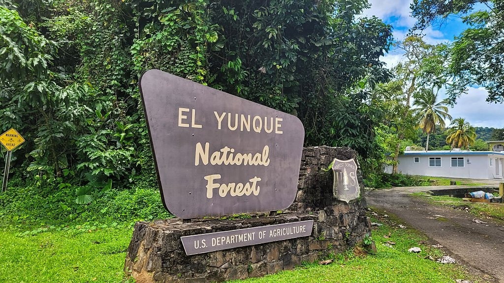
In the northeast of Puerto Rico, El Yunque offers a very different face from the seaside island often promoted. Here, the road climbs up to a humid, wooded relief crossed by mountain rivers. It is the only rainforest massif in the U.S. National Forest System. It extends over eight municipalities and covers just over 110 km², making it a relatively small area, but one of remarkable biological richness.
El Yunque, a natural site in a class of its own in Puerto Rico
Talking about El Yunque is not talking about Puerto Rico as a whole, but about a specific, clearly identified place, with its geography, climate and history. This precision makes it a strong subject both editorially and SEO-wise. The massif is located in the Sierra de Luquillo, with an altitude that climbs to over 1,000 meters. Over this gradient, the average annual temperature varies from approximately 25 to 19°C, while annual rainfall ranges from around 2,000 to 5,000 mm. This combination explains the density of vegetation, the constant presence of water and the impression of freshness that marks the visit.
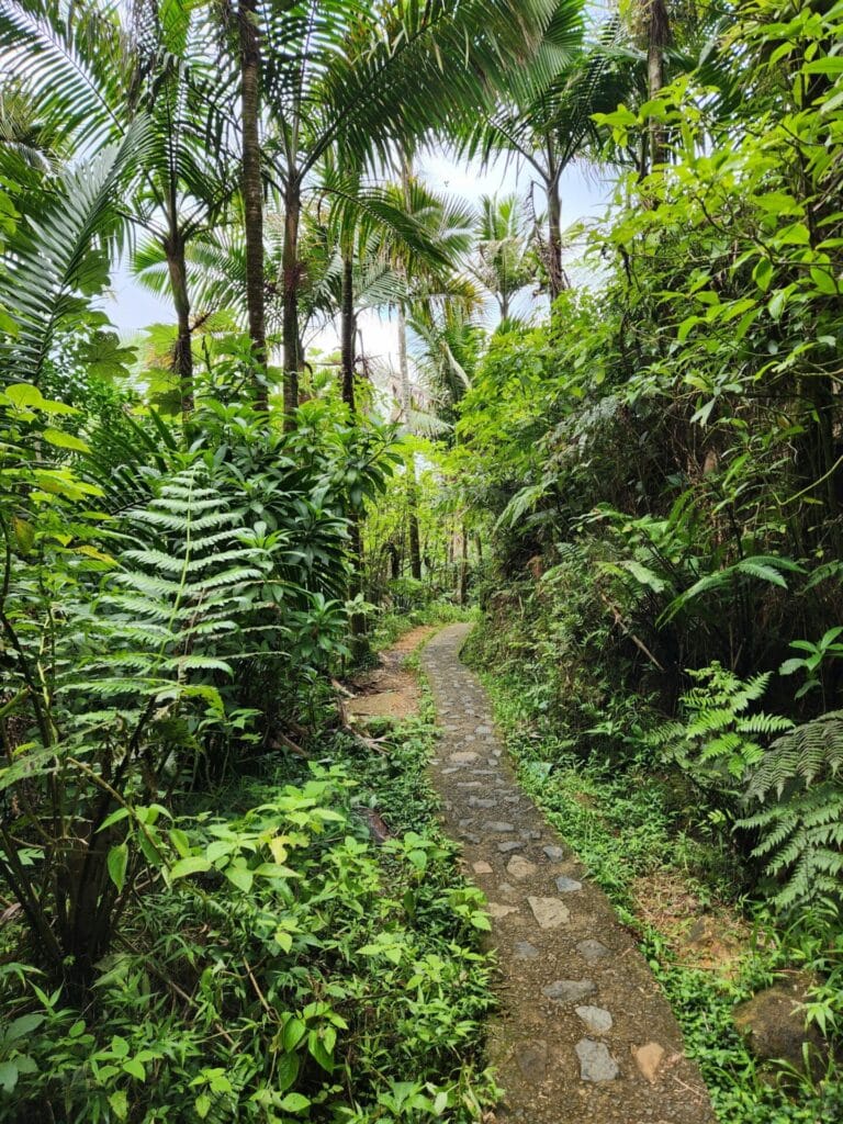


A forest where water, relief and climate shape the landscape
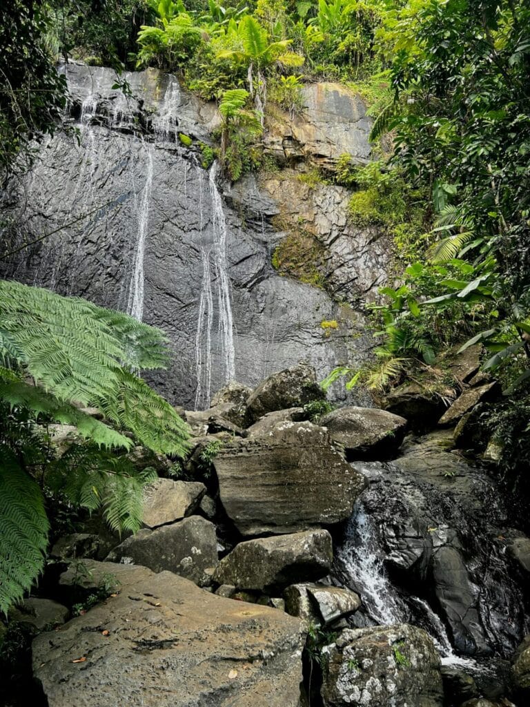
El Yunque is more than just a closed, uniform forest. Relief plays a central role. The slopes capture the moisture carried by the trade winds, nourishing the soils and feeding the rivers, some of which remain among the island’s best preserved. This setting gives rise to a succession of landscapes: very wet undergrowth, unobstructed views of the mountains, fast-flowing streams, natural pools and waterfalls that are accessible depending on which sectors are open to the public. The result is an experience that is more inward, more plant-based and often quieter than the major coastal sites.


El Yunque and its exceptional biodiversity
One of the great attractions of El Yunque is its biodiversity. Official data indicate that the forest is home to 13 of the 17 species of coquí recorded in Puerto Rico. This small amphibian is much more than a curiosity: it’s part of the island’s sonic identity. The site is also home to 97 species of birds, including 45 migratory species, as well as numerous species of reptiles, freshwater fish, shrimp and invertebrates. Among the most symbolic species is the Puerto Rican parrot, which has been closely associated with conservation efforts in the area for decades.


The coquí, El Yunque's signature sound
For many visitors, El Yunque is as much about seeing as hearing. The song of the coquí accompanies the wetlands and immediately reminds us that this forest is not simply a place for strolling, but a living environment where each species occupies a precise place. This is also what gives the site its strong identity in the face of other destinations more focused on the coast.

A long history of protection and research
El Yunque owes its reputation not only to its scenery. Its institutional history is equally important. In 1876, King Alfonso XII of Spain proclaimed a 10,000-hectare forest reserve in the Luquillo mountains. Today, this decision makes it one of the oldest protected forest reserves in the Western Hemisphere. In 1903, Theodore Roosevelt established the Luquillo Forest Reserve, the future nucleus of today’s El Yunque. Over time, the site has also become a major area for scientific research, to the point of being one of the most studied tropical forests in the world.


Why is El Yunque so attractive?
The site attracts visitors for several reasons. Firstly, there’s the promise of an easily identifiable, world-famous tropical rainforest. Then there’s the diversity of possible experiences: walking, observing vegetation, discovering waterways, reading the mountain landscape, a more concrete approach to Puerto Rican biodiversity. Last but not least, it still receives little in-depth treatment in French-language content, even though it has a strong international reputation. It is precisely this discrepancy that makes it a relevant subject to work on.

Access to the site requires checking the latest conditions. Entry via the recreational corridor on PR-191 North in Río Grande is free and does not require a reservation at present, but use remains regulated due to limited parking and ongoing work. Several trails remain closed, including La Mina Trail, Big Tree Trail and Baño de Oro Trail. The trail to El Yunque Peak is open only as far as Los Picachos, the rest remaining closed for safety reasons.
El Yunque National Forest is located in northeastern Puerto Rico, mainly in the municipalities of Río Grande and Luquillo. The massif belongs to the Sierra de Luquillo and is about 45 minutes’ drive from San Juan. This location makes it an accessible excursion while offering a radically different environment from the capital, with its mountainous terrain and much wetter climate.
El Yunque is the only example of tropical rainforest within the U.S. National Forest System. This makes it both a rare and much-studied site. Its ecological richness is based on a combination of factors: altitude, high rainfall and habitat diversity. Over a relatively compact area, it concentrates several types of forest and a large number of endemic species, which clearly distinguishes it from other natural areas in the region.
A visit to El Yunque includes hiking trails, mountain rivers, natural pools and several viewpoints over the massif. Some areas offer access to waterfalls, while others offer a more gradual immersion in the forest. The site also features a visitor center, with educational information on the fauna, flora and history of the area. Depending on the area opened up, the experience can vary from an accessible stroll to a more strenuous hike.
Yes, we strongly recommend that you check the access conditions before visiting the site. Access to the site is restricted due to the limited number of parking spaces available and the fact that some work is still in progress. Not all trails are permanently open, and some areas may be temporarily closed for safety reasons. Consult the official information to avoid unpleasant surprises and optimize your itinerary on site.
El Yunque can be visited all year round, but conditions vary from season to season. As the forest is humid by nature, showers are frequent, even in the so-called dry season. The months from December to April generally offer more stable conditions, while the period from May to November can be rainier, with an increased risk linked to the hurricane season. In all cases, we advise you to bring suitable footwear, water and clothing to cope with the humidity.
Blue Lagoon Island puts the spotlight back on a rare page of Bahamian heritage. Last week, the destination marked the centenary of its iconic Watch Tower, built in 1926 and now back at the heart of the island’s cultural narrative. Behind the commemorative event is the desire to anchor a tourist site in history, to give it back a heritage depth, and to make it a landmark for today’s visitors as well as those of tomorrow.
In Nassau, this type of initiative is by no means insignificant. In a region where tourism is often told through beaches, excursions and leisure activities, the spotlight on a century-old monument serves as a reminder that the experience of a territory also involves the memory of places. With this official rededication, Blue Lagoon Island does more than simply restore an ancient structure. Blue Lagoon Island is reaffirming the place of its heritage in its contemporary identity.
A century-old tower at the heart of the island's story
The ceremony to mark the Watch Tower’s 100th anniversary set the tone. A new commemorative plaque was unveiled, while an anniversary banner was unfurled from the top of the three-storey masonry structure. The symbolism is strong: the tower is not treated as a mere decorative relic, but as a living witness to Bahamian history.
Built in 1926 by Chicago architect Howard Van Doren Shaw, the Watch Tower has survived the decades without losing its evocative power. In preparation for this new chapter, the interior has recently been refurbished with a new staircase and reinforced floor. This work is not simply a matter of maintenance; it reflects a clear desire to open the tower up to a new century of use, while making it more accessible to visitors.
The presence of John T. McCutcheon at the blessing of the site added a family and historical dimension to the event. McCutcheon, Pulitzer Prize-winning cartoonist and war correspondent, is presented as the visionary figure behind this achievement. Through this filiation, Blue Lagoon Island links architectural heritage, private memory and collective heritage.


Blue Lagoon Island between memory and tourism strategy
Blue Lagoon Island‘s general manager, Robert Meister, summed up the ambition of this approach by describing the Watch Tower as a sentinel of the past and a beacon for the future. This phrase says a lot about what’s at stake today: preserving the monument, yes, but above all giving it a function in the present. The tower is no longer just an old communications post; it is becoming a structuring element of the experience offered on Blue Lagoon Island, at the crossroads of history, culture and tourist appeal.
This understanding of heritage was reinforced by a presentation from Latia Duncombe, Director General of Tourism for the Bahamas. Her speech placed the conservation of the site within a broader strategy, in which identity is an essential resource for tourism development. From this perspective, Blue Lagoon Island illustrates an idea that is increasingly important in the Caribbean: a territory gains strength when it relies not just on its commercial potential, but also on what makes it singular, rooted and recognizable.
For professionals in the Caribbean tourism industry, this orientation deserves attention. It shows that a leisure site can enrich its positioning by highlighting specific historical elements, rather than by confining itself to uniform communication. On a regional scale, where many destinations are seeking to better articulate tourism and heritage, the choice made by Blue Lagoon Island seems particularly coherent.
The Watch Tower, a place full of symbols
The interest of the tower lies not only in its age. The building also preserves material traces linked to one of the best-known stories in Bahamian popular heritage: that of “Sloop John B.” The structure permanently houses two original artifacts from the ship that inspired this now world-famous song: a fastening ring and a piece known as the “knee of horseflesh”.


And there’s another remarkable detail: stones from Vendue House, Fort Charlotte, Fort Montagu and Fort Fincastle have been incorporated into the tower, alongside artifacts from other historic sites around the world. This accumulation of material, references and origins gives the Watch Tower a heritage value that goes beyond its mere silhouette. It acts as an assemblage of memories, a meeting point between local history and wider resonances.

A celebration prolonged by the showcasing of local products
After the ceremony, guests were welcomed to Serenity Cove, the recently renovated adults-only space. This was no mere reception. It served to showcase Bahamian businesses, through products such as bush teas, rum cakes and locally made ice creams. It’s an important gesture, as it links heritage preservation with economic and cultural support for the local fabric.
This combination of history, hospitality and the promotion of local know-how adds substance to the event. It prevents the centenary from being confined to a ceremonial sequence. Blue Lagoon Island shows that a heritage anniversary can also become a showcase for a certain idea of sustainable tourism, based on the visibility of local players and a more authentic experience for visitors.
A tourism experience that also relies on education
Blue Lagoon Island is also developing an offer centered on educational, sustainable and interactive experiences around the marine environment. Encounters with dolphins, stingrays and nurse sharks, the presence of California sea lions, educational activities and eco-nature walks: all these elements make up a tourist offer that seeks to combine leisure and awareness.
The Watch Tower is now fully in line with this logic. Visitors can discover it and climb to the top as part of a guided Eco-Nature Walking Tour, with views presented as spectacular. This detail is as important for SEO as it is for editorial interest: it provides a concrete answer to a question that readers and travelers are asking, namely what it’s possible to do on site today.


Blue Lagoon Island is located near Nassau, the capital of the Bahamas. This private island is renowned for its ecotourism experiences and marine activities, but is also distinguished by its historical heritage. The presence of the Watch Tower, built in 1926, reinforces its cultural importance. Today, Blue Lagoon Island is more than just a seaside destination: it’s part of a strategy to enhance Bahamian history, offering visitors a natural, educational and heritage immersion experience.
The Watch Tower on Blue Lagoon Island was built in 1926 by American architect Howard Van Doren Shaw. Originally, it served as a strategic communication point. Over time, it has become a symbol of the island. It is also linked to the story of John T. McCutcheon, a Pulitzer Prize-winning journalist and cartoonist whose family is associated with the site. Today, the tower preserves historical artifacts, notably linked to the song “Sloop John B.”, making it a unique site blending architecture, family memory and Bahamian popular culture.
Blue Lagoon Island offers a wide range of activities that go far beyond sightseeing. Visitors can take part in encounters with dolphins, rays and nurse sharks. The island also offers guided eco-nature tours, including access to the Watch Tower with its panoramic views of the surrounding area. Spaces like Serenity Cove offer a more exclusive setting, while local products (herbal teas, pastries, ice cream) are featured to enrich the experience. The result is a complete visit, combining leisure, culture and environmental awareness.
Blue Lagoon Island is committed to sustainable tourism, combining environmental preservation, education and the development of local stakeholders. The island is certified by internationally recognized animal welfare and conservation organizations. It offers educational activities focusing on marine wildlife and features products from Bahamian businesses. The restoration of the Watch Tower is also part of this approach, integrating historical heritage into the tourism experience. This approach allows us to offer a more responsible form of tourism, rooted in the local area.
A visit to Blue Lagoon Island reveals another facet of the Bahamas. Beyond the beaches, the island offers an experience enriched by history, culture and nature. The Watch Tower, recently restored for its centenary, is a highlight of the visit, adding a rare dimension of heritage. The activities on offer, the quality of the facilities and the attention paid to the environment make this a complete destination. For travelers looking for an authentic, structured experience, Blue Lagoon Island represents a relevant stopover during a stay in the archipelago.
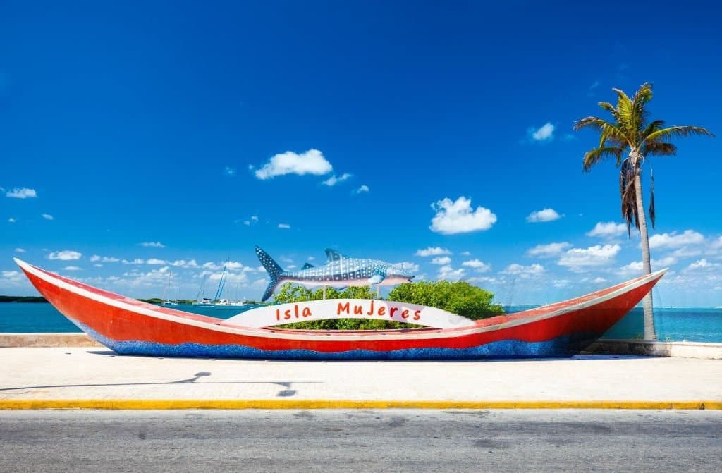
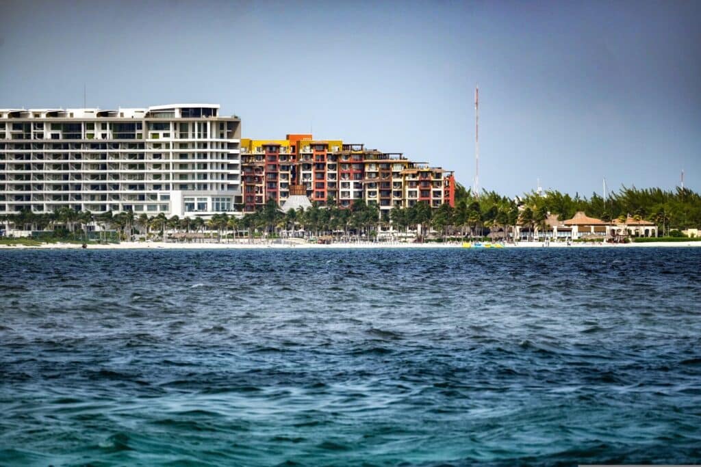
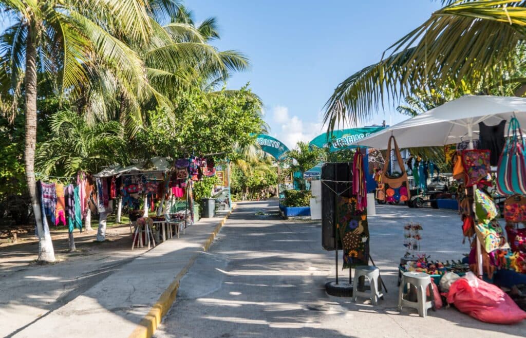
Opposite Cancún, in the state of Quintana Roo, Isla Mujeres occupies a special place in the Mexican Caribbean. The island is short, narrow and easy to navigate, but its appeal goes far beyond its size: there’s a lively seafront, a more exposed east coast offshore, quiet beaches to the north, an archaeological site associated with the Mayan goddess Ixchel and a clear relationship between tourism, local life and landscape.
An island that's close to Cancún, but distinct in its operation
Just 13 kilometers off the Yucatán coast, Isla Mujeres can be reached by ferry from Cancún in around 20 minutes, depending on the departure point and operator. This proximity explains its international reputation, but it should not obscure what makes it so unique: the island functions as a small-scale autonomous territory, with its own center, beaches, residential neighborhoods and areas more open to the sea. The island is some 7 kilometers long and 650 meters wide at its narrowest point, reinforcing the impression of a space that is easy to read, almost immediate, from the moment you arrive.
This accessibility is one of the area’s strengths for tourists. Visitors can spend several days here without having to rely on cumbersome logistics, while enjoying a distinct change of atmosphere from the mainland coast. Where Cancún relies on a more vertical, dense and fast-paced organization, Isla Mujeres maintains a more horizontal rhythm, centered on walking, short trips and a direct relationship with the seaside. It’s this difference in pace that partly explains Isla Mujeres’ appeal to travellers looking for a clearer stay.
A coastal territory organized between Playa Norte village and Punta Sur
The north of Isla Mujeres concentrates most of the tourist traffic. This is where you’ll find the main ferry terminal, the shopping streets and, above all, Playa Norte, the island’s best-known beach. Its reputation rests on several concrete elements: clear sand, shallow waters, generally calm areas and easy access from the center. For families, travellers who want to swim without difficulty, or simply stay a long time at the water’s edge, this area functions as an immediately understandable seaside heart.
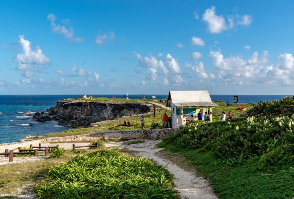
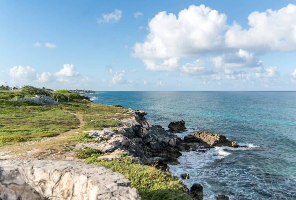
But it would be a mistake to reduce Isla Mujeres to Playa Norte. The further south you go, the more the face of the island changes. The relief becomes a little more pronounced, the eastern coast faces a more open sea, and Punta Sur introduces a different reading of the territory. This promontory is home to the remains of a Mayan sanctuary linked to Ixchel, a goddess associated with fertility, medicine and the moon in the Mayan world. This archaeological presence gives the island a real historical depth, often overlooked in purely seaside narratives.


A Caribbean identity between Mayan heritage and local life
The name Isla Mujeres refers precisely to this heritage. According to commonly accepted historical and archaeological accounts, the Spaniards found female figures on the island associated with the cult of Ixchel, which helped establish the name “Island of Women”. This is no mere detail of toponymy: it is a reminder that the territory already existed as a place of circulation, worship and landmark in the Caribbean before the structuring of contemporary tourism.
Even today, this memory coexists with a visible local life. The streets in the center of the town are a mix of restaurants, stores, accommodation and everyday services. Fishermen, shopkeepers, locals and visitors often use the same spaces. This is what makes Isla Mujeres particularly interesting for a feature article: the island doesn’t function as a showcase isolated from reality, but as a small inhabited territory where tourist activity remains integrated into the urban fabric. For your readers, this is a real added value, because it enables them to think about the destination beyond the images of the beach.

A strong tourist destination, but still easy to understand
For tourists, Isla Mujeres offers a clear advantage: everything is close without looking the same. You can alternate between a day on the beach, a visit to Punta Sur, a stroll through the center, a more leisurely coastal route and marine activities linked to the island’s clear waters. The short crossing from Cancún further enhances this flexibility.
It’s also a destination that works well for different profiles: couples, families, solo travelers or visitors who want to extend a stay in Quintana Roo with a quieter stopover. The island is still a tourist destination, and sometimes very busy, but its size means that you can still get a clear sense of the space. And that’s precisely where its strength lies: Isla Mujeres isn’t just a pretty getaway from Cancún, it’s a coherent territory, with a history, an identifiable geography and a real capacity to offer a different relationship with the Caribbean coastline.

Another way to enter the Mexican Caribbean
Highlighting Isla Mujeres today means offering your readers a famous destination, but approached with a more territorial eye. The island doesn’t just rely on the beauty of its northern seaside resort; it benefits from being understood in its entirety, between rapid sea access, Mayan heritage, coastal contrasts and local life that is still present.
In the highly competitive landscape of the Mexican Caribbean, Isla Mujeres holds a special place: that of a small but structured area, where the relationship between sea, history and contemporary uses can still be clearly seen.
Isla Mujeres lies in the Caribbean Sea, some 13 kilometers off Cancún, on the northeast coast of Mexico’s Yucatán Peninsula. The main access is by ferry, with regular departures from Puerto Juárez, the Cancún hotel zone or Punta Sam. The crossing generally takes between 15 and 25 minutes, depending on the point of departure. This proximity makes it easy to organize a multi-day stay or an excursion, while benefiting from an island environment distinct from the mainland coast.
Unlike Cancún, which has developed around a dense hotel zone structured for mass tourism, Isla Mujeres retains a much smaller scale. The island functions as a compact territory where local life remains visible. Travel is short, often on foot, by bike or in a buggy, and spaces are shared between residents and visitors. This configuration creates a more legible atmosphere, with a direct link to the sea, shops and residential areas. For travelers, this means a calmer, less segmented experience, more rooted in the island’s everyday life.
Isla Mujeres is not limited to its beaches, although Playa Norte remains one of the major attractions for swimming and relaxing. The island also offers the chance to discover Punta Sur, home to the remains of an ancient Mayan site dedicated to the goddess Ixchel, adding a historical dimension to your stay. It’s also possible to explore the more exposed and less crowded eastern coastline, or stroll through the city center, with its lively streets, restaurants and markets. Water sports, such as snorkeling, are available in several areas. Last but not least, the island’s size means you can enjoy a wide variety of experiences without logistical constraints, making it an ideal destination for both short and extended stays.
In the southern Caribbean, off the coast of Venezuela, Bonaire is a territory in a class of its own. Less publicized than its neighbors Aruba and Curaçao, the island has built its identity around one central principle: the protection of its environment. Here, the sea structures the economy, landscapes and customs, while tourism development has been gradual and controlled. For travelers, Bonaire offers a clear picture: a compact island, visible natural areas, an accessible coastline and an organization geared towards sustainability.
An island structured by its marine park
Since 1979, Bonaire’s entire coastline has been protected by the Bonaire National Marine Park which completely surrounds the island. This marine area regulates nautical activities and aims to preserve the coral reefs, considered among the best preserved in the Caribbean. One of the island’s special features is the direct accessibility of its marine sites. Diving and underwater observation can be carried out from the coast, without the need for a boat. Marked access points allow visitors to enter the water without disturbing protected areas. This model of environmental management has made it an international benchmark for marine conservation. It attracts a specific public, attentive to the quality of ecosystems and the regulation of uses.
An arid, contrasting landscape
Contrary to the classic image of the tropical Caribbean, Bonaire has a drier landscape. The island is characterized by semi-arid vegetation, modest relief and vast open areas. This is due to its position south of the hurricane belt and a more stable climate, with limited rainfall. To the north, the Washington Slagbaai National Park covers a large part of the territory. This terrestrial reserve protects a diversity of environments: hills, rocky coasts, wetlands and habitats for numerous bird species. It offers a different view of the island, one that complements that of the coastline.


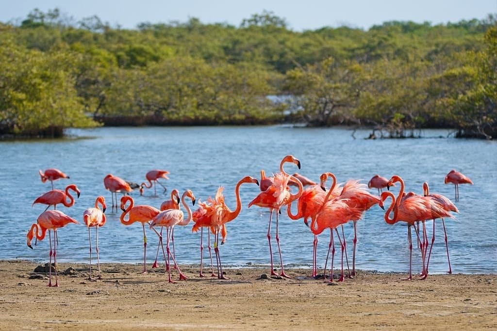
The saltworks, an emblematic landscape
To the south of Bonaire, the salt pans are a striking feature of the landscape. Exploited for centuries, they form vast basins where seawater is evaporated to produce salt. The colors vary from pink to white, depending on the concentration of salt and the micro-organisms present. These areas also attract colonies of pink flamingos, which find favorable conditions in these environments. Their presence reinforces the ecological interest of the site and contributes to the island’s visual identity.


A capital on a human scale
Kralendijk, Bonaire’s capital, concentrates administrative, commercial and tourist activities. The town is characterized by its colorful buildings, open waterfront and simple organization. The town’s limited infrastructure means that traffic flows smoothly and there’s a direct link to the coast. Daily life is visible: local shops, markets, services and interaction between residents and visitors. This proximity contributes to a more direct experience of the area.


Supervised, specialized tourism
Tourism has developed around specific niches, notably diving and nature observation. The island does not rely on large, massive complexes, but on human-scale structures: hotels, apartments and villas. Visitors generally come for longer stays, with a focus on the environment. This orientation limits tourist pressure and favors a more stable economic model.
Access and organization
Bonaire is accessible via Flamingo International Airport, with connections to North America, Europe and the Caribbean. Locally, travel is mainly by car, making it easy to explore the whole island. The organization of your stay is often based on an alternation between marine activities, exploration of natural areas and rest periods. The island lends itself to progressive discovery, without excessive concentration of sites.

A different Caribbean
Highlighting Bonaire means proposing a different interpretation of the Caribbean. The island’s approach is not based on volume, but on the preservation and rational use of resources. For travelers, Bonaire offers a coherent experience: a clear territory, an accessible sea, distinctive landscapes and environmental management. It is for those who seek to understand the territory as much as to enjoy it, in a Caribbean where nature remains central.
Bonaire lies in the southern Caribbean, off the coast of Venezuela, alongside Aruba and Curaçao. The island is part of the Dutch Caribbean and is a special municipality of the Netherlands. It is accessible via Flamingo International Airport, with regular flights from Amsterdam, the USA and several Caribbean islands. Once on the island, travel is mainly by car, making it easy to cover the entire territory.
Bonaire is internationally renowned for the quality of its coral reefs and for its model of environmental management. Since 1979, the Bonaire National Marine Park has protected its entire coastline. One of its key features is direct access to dive sites from the coast, without the need for a boat. More than 80 marked dive sites enable you to observe coral, tropical fish and other marine species, often in very favorable conditions. This accessibility, combined with strict regulations, contributes to the preservation of the island’s ecosystems and its reputation.
Bonaire mainly attracts travelers looking for an unspoilt environment and a quieter form of tourism. The island is particularly popular with lovers of diving, nature and wildlife observation. It is also ideal for those wishing to avoid the big seaside resorts and opt for a more autonomous stay, with a more relaxed pace. Tourism is deliberately kept to a minimum, allowing a more direct experience of the territory.
The partnership between CTO and The Travel Foundation marks an important step in the evolution of tourism policies in the Caribbean. At the ITB Berlin 2026 international trade fair, the region’s tourism leaders confirmed that they would strengthen their cooperation to support a more sustainable tourism model, more resilient to climate change and more focused on local communities.
In a region where the economy is heavily dependent on tourism, climate change is no longer an abstract issue. The effects of global warming, the intensification of weather phenomena and the erosion of coastal ecosystems now represent immediate challenges for many island territories. It is against this backdrop that the partnership between CTO and The Travel Foundation takes on a strategic dimension. The objective is clear: to transform climate commitments into concrete actions capable of supporting the economic and social future of Caribbean destinations.
ITB Berlin, a strategic venue for the voice of the Caribbean
Every year, ITB Berlin brings together the world’s key tourism players: ministries, international organizations, airlines, destinations and industry experts. For the Caribbean, this event is an essential platform for recalling a reality that is often underestimated on an international scale: small island states are among the territories most exposed to the effects of climate change.
At a session devoted to the gap between climate risks and adaptation solutions in tourism, the Secretary General and CEO of the Caribbean Tourism Organization, Dona Regis-Prosper, highlighted the region’s real-life experience. The devastating hurricanes that regularly hit the Caribbean, rising sea levels and increasing pressure on marine ecosystems have had a profound impact on the territories. Today, this first-hand experience is a driving force for rethinking the region’s tourism strategies. The partnership between CTO and The Travel Foundation is precisely in line with this dynamic of transformation.

Moving from climate talk to concrete solutions
At the heart of the partnership between CTO and The Travel Foundation lies one overriding conviction: climate strategies must now go beyond declarations of intent. Caribbean destinations already have numerous studies, scientific data and prospective scenarios on climate risks. However, a persistent challenge remains: transforming this information into genuinely funded and operational projects.
This is one of the points raised by Narendra Ramgulam, Deputy Director of Sustainable Tourism at the Caribbean Tourism Organization. According to him, the region has no shortage of ideas and analyses, but the concrete implementation of projects is often hampered by a lack of access to funding. In this context, the partnership between CTO and The Travel Foundation aims to bridge the gap between strategic planning and real action on the ground.

A tourism model focused on local communities
One of the major thrusts of the partnership between CTO and The Travel Foundation concerns the role of local populations in tourism development. In many Caribbean destinations, the economic benefits of tourism sometimes remain concentrated in certain segments of the industry. The new cooperation framework aims to foster a more inclusive approach in which tourism projects generate direct benefits for communities.
This vision also implies a strengthening of local skills in sustainable tourism professions, as well as increased support for economic initiatives that enhance the region’s natural and cultural resources. This approach is in line with a global trend in the tourism sector. Today’s travelers are increasingly interested in responsible, authentic experiences that are closely linked to the realities of the areas they visit.
Caribbean tourism faces structural transformation
The partnership between CTO and The Travel Foundation comes at a pivotal time for the Caribbean tourism industry. Several profound transformations are redefining the future of the sector. The intensification of extreme climatic phenomena, the gradual weakening of coral reefs, the erosion of certain beaches and the evolution of travelers’ expectations in terms of sustainability are gradually changing the balance of regional tourism.
These elements are not just about the environment. They directly influence the tourism experience, the competitiveness of destinations and the livelihoods of many local populations. Against this backdrop, strengthening the resilience of Caribbean tourism is becoming as much an economic priority as an environmental one.
International cooperation to strengthen resilience
The renewal of the partnership between CTO and The Travel Foundation formalizes a strengthened collaboration between two organizations committed to the transformation of global tourism. The Travel Foundation has been working for several years on initiatives to make tourist destinations more sustainable, notably through climate planning, tourism flow management and ecosystem protection.
For its part, the Caribbean Tourism Organization represents the tourism interests of many of the region’s territories and plays a central role in coordinating regional policies. By combining their expertise, the two institutions aim to develop tools and strategies that will enable Caribbean destinations to better anticipate climate risks, while maintaining their attractiveness to tourists.
A regional vision for the future of Caribbean tourism
Beyond technical cooperation, the partnership between CTO and The Travel Foundation is also part of a broader vision: that of a coordinated regional approach to sustainable tourism. The Caribbean shares many common realities. The economies of many territories rely heavily on tourism, the islands remain particularly exposed to climatic risks, and the region boasts an exceptional natural and cultural heritage.
In view of these common characteristics, regional cooperation appears to be an essential lever for developing solutions tailored to the specific characteristics of island destinations. This approach is also in line with the ambitions of the CTO Reimagine Plan, a strategy that aims to reposition Caribbean tourism around sustainability, innovation and resilience.
The Caribbean, a global laboratory for sustainable tourism
Through the partnership between CTO and The Travel Foundation, the Caribbean is also seeking to assert its role in international debates on the future of tourism. The challenges facing the region today could foreshadow those that other tourist destinations will have to face in the coming decades. From this perspective, the Caribbean can become a veritable laboratory of innovation for climate-resilient tourism strategies, sustainable management of island destinations and the integration of communities into the tourism economy.
The stakes involved in the partnership between CTO and The Travel Foundation extend far beyond regional borders. The solutions developed in the Caribbean could inspire other regions of the world facing similar challenges.
The partnership aims to develop concrete strategies to make Caribbean tourism more resilient in the face of climate change, while supporting local communities.
Caribbean destinations have to cope with intensifying hurricanes, beach erosion, coral reef degradation and rising sea levels.
The Caribbean Tourism Organization aims to position the Caribbean as a sustainable destination, capable of reconciling tourism development, ecosystem protection and benefits for local populations.
On the southwest coast of Saint Lucia, near the town of Soufrière, Anse Chastanet is one of the most remarkable sites on the Caribbean coast. This bay, bordered by tropical hills and facing the Caribbean Sea, combines a preserved natural environment, a discreet historical heritage and one of the island’s most accessible reefs. Today, Anse Chastanet is an ideal vantage point for travellers with a keen eye for the landscape and marine life of the Caribbean islands.
A natural bay in the heart of Saint Lucia's volcanic coastline
Anse Chastanet lies a few kilometers north of Soufrière, on a stretch of coast dominated by volcanic relief and tropical forests. The landscape is characteristic of this part of Saint Lucia: steep hills covered in vegetation, a deep sea close to shore and, offshore, the silhouette of the Pitons, two volcanic mountains listed as a UNESCO World Heritage Site.
The bay itself is relatively protected, which explains the clarity of the waters and the richness of the marine ecosystem. The sand here is of volcanic origin and often has a dark hue, typical of many beaches in the south of the island. This geological configuration is a reminder that Saint Lucia is first and foremost a volcanic island, where sea and mountain coexist within a very short distance.

A reef accessible directly from the beach
One of the things that sets Anse Chastanet apart in the Caribbean is its close proximity to the coral reef. Just a few meters from the shore, visitors can observe a marine zone rich in tropical fish and coral formations. The reef starts around ten meters from the water’s edge and then develops into a plateau before gradually descending to greater depths. This configuration allows snorkeling directly from the beach. Over 150 species of fish have been recorded in this area, making it one of Saint Lucia’s best-known coastal diving sites.
To protect this fragile environment, certain areas of the reef are marked to prevent boat access. This organization helps to preserve the marine fauna while ensuring safe viewing for visitors.

A beach open to the public
Although the bay is associated with a hotel establishment, Anse Chastanet beach remains open to the public. Visitors can spend the day here, swimming or snorkeling, even if they are not staying in nearby accommodation. This accessibility contributes to the site’s popularity, particularly with travelers exploring the Soufrière coast. On-site services include restaurants, a diving center and water sports facilities.
A coastal path also leads to the nearby beach of Anse Mamin, just a few minutes’ walk away. This second, more discreet bay is surrounded by the remains of an old colonial plantation.


A site marked by the history of plantations
Behind Anse Chastanet beach lie the ruins of a plantation dating back to the XVIIIᵉ century. These remains bear witness to Saint Lucia’s agricultural history, when sugar production dominated the island’s economy. Today, these traces of the past are integrated into the landscape. Trails allow visitors to explore the ancient stone structures and observe how tropical vegetation has gradually reclaimed the site.
This historical presence adds an extra dimension to the visit: Anse Chastanet is not just a beach, but also a place where colonial history, nature and tourism meet.
A bay integrated into a protected environment
The Anse Chastanet area lies at the heart of Saint Lucia’s marine reserves. These protected areas were set up to preserve the coral reefs and marine ecosystems surrounding the island. This environmental management is essential to maintain the balance between tourism and conservation of the natural environment. Nautical activities are therefore restricted, and certain areas are reserved exclusively for underwater observation.

A destination representative of the natural Caribbean
Anse Chastanet encapsulates several major characteristics of the Caribbean landscape: a sea rich in biodiversity, a dense tropical forest and a coastline shaped by volcanic activity. This combination explains why the bay attracts divers, photographers and travelers in search of an unspoilt environment. Located in one of Saint Lucia’s most spectacular regions, in the immediate vicinity of the Pitons and the mountainous relief of the island’s south, Anse Chastanet offers a clear reading of the local geography. It is a reminder that the Caribbean is not just about beaches, but also about landscapes, history and marine ecosystems.
For visitors wishing to explore Saint Lucia beyond the classic seaside resorts, Anse Chastanet is today a benchmark site, where nature, sea and heritage meet in a relatively unspoilt area.
Anse Chastanet is located on the southwest coast of Saint Lucia, near the town of Soufrière, in the Caribbean Sea.
The bay is renowned for its coral reef, accessible directly from the beach, which is home to over 150 species of fish and is one of the island’s best-known dive sites.
Yes, the beach at Anse Chastanet is open to the public, and visitors can enjoy swimming, snorkeling or any of the services available on site.
From May 22 to 27, 2026 Grenada will host a new edition of the Grenada Chocolate Fest 2026. Over the years, this event has become one of the most unique on the island’s gastronomic and cultural calendar. The theme of this year’s event is an ambitious one: “Reimagining Caribbean Cocoa – From Roots to Renaissance”, an invitation to rethink cocoa from its historical roots and imagine new perspectives.
For six days, producers, chocolatiers, chefs, artisans, researchers, locals and visitors from all over the world come together to celebrate cocoa in all its forms: agriculture, gastronomy, well-being, creation and cultural transmission. More than just a gourmet festival, Grenada Chocolate Fest 2026 offers a complete immersion in the world of Grenadian cocoa, from the plantations to the artisanal creations that have made the island’s chocolate world famous.

A story born of a passion for Grenadian cocoa
Grenada Chocolate Fest 2026 is part of a story that began in 2014, when Grenada decided to put the spotlight on one of its most precious agricultural heritages: cocoa.
The festival was conceived to promote the “tree-to-bar “tree-to-bar”, an approach that involves mastering every stage of chocolate production, from growing the cocoa to making the bar. This vision was developed in Grenada by a number of entrepreneurs and craftsmen who were convinced that cocoa could become a true symbol of the island’s identity.
Among the key figures in this story are Mott Green founder of the Grenada Chocolate Company, whose commitment to sustainable, artisanal, solar-powered chocolate has had a profound impact on the development of the industry on the island. Since its inception, the festival has pursued a clear objective: to enable visitors and locals alike to understand the complete cocoa journey, from plantation to finished product, while promoting the farmers, artisans and communities who perpetuate this know-how.


A festival that grew with the cocoa industry
Over the years, the festival has gradually gained international recognition in the world of artisan chocolate and gastronomic tourism. Today, each edition attracts fine cocoa experts, chefs, culinary innovators and local producers, as well as visitors from the Caribbean, Europe and North America.
This development also reflects the transformation of Grenada’s cocoa sector. The island is now renowned for the quality of its cocoa and for the presence of several companies specializing in the production of artisanal chocolate. Against this backdrop, Grenada Chocolate Fest 2026 is part of a wider dynamic: that of a region transforming its agricultural heritage into a cultural, economic and tourism driver.


The Grenada Chocolate Fest 2026 program
The 2026 edition offers six days of varied activities. Each day is designed as a journey to explore cocoa from different angles. Each day is designed as a journey to explore cocoa from different angles.
May 22: festival opening and first chocolate experiences
The festival kicks off with a series of meetings and events dedicated to the cocoa industry. The first day brings together producers, specialists and enthusiasts for discussions and exchanges on the future of cocoa, while offering a number of experiments to help visitors understand the first stages of chocolate processing.
Participants can attend lectures dedicated to cocoa, discover an exhibition devoted to artisanal products, take part in a chocolate candy-making workshop or create their own chocolate bar. The day ends with a festive evening at a historic estate on the island, marking the official opening of the festival.
May 23: well-being, gastronomy and family activities
The second day focuses more on sensory experience and well-being. Cocoa is explored as a gastronomic ingredient, but also as an element associated with health, relaxation and creativity. A number of experiments are proposed around cocoa and superfoods, while a cocoa village hosts family activities and interactive workshops to discover the different flavors of chocolate.
Culinary demonstrations and tastings punctuate the day, which concludes with a gourmet dinner showcasing the products and culinary talents of Grenada.
May 24: immersion in nature and cocoa plantations
The third day invites participants to discover cocoa in its natural environment. A hike explores some of the island’s most emblematic landscapes, notably in the direction of a waterfall, while an artistic brunch offers an original encounter between gastronomy and creation. A culinary demonstration inspired by Rastafari culture also illustrates the links between cocoa, traditions and Caribbean cuisine. One of the highlights of the day is an immersive tour of a historic cocoa estate, where visitors can observe the various stages of cocoa production. The day ends with a festive chocolate party.
May 25: chocolate, perfumes and the Grenadian art of living
The fourth day of the festival highlights the Grenadian art of living. Participants can start the day with a yoga session accompanied by a cocoa butter massage, before setting off to discover some of the island’s secret beaches on a guided walk. A gastronomic tour then explores local flavors, while a cocoa and fragrance experience highlights the links between chocolate, spices and aromatherapy. A gastronomic tasting in a prestigious setting completes this day dedicated to the senses.
The day continues with a market of local artisans and artists, accompanied by musical entertainment celebrating Grenadian culture.
May 26: passing on chocolate-making know-how
The fifth day of the Grenada Chocolate Fest 2026 emphasizes transmission and learning. Visitors can take part in experiments combining rum and chocolate, discover the island’s culinary specialities on a gastronomic tour, or learn how to make chocolate sweets alongside local artisans.
There are also workshops where you can plant a cocoa tree and make your own chocolate bar, giving you a hands-on experience of the work of cocoa growers and chocolatiers.
May 27: artistic creation and closing party
The final day of the festival celebrates creativity and conviviality. Participants can discover a natural spa inspired by cocoa, take part in an artistic workshop combining chocolate and spices, or create jewelry from cocoa beans. An introduction to the traditional process of making the cocoa balls used to prepare Grenadian tea also introduces participants to a culinary practice that is emblematic of the island. The festival concludes with a culinary and musical street party, marking the end of a six-day celebration of Grenadian cocoa.


A festival open to families
Grenada Chocolate Fest 2026 is also designed as an event accessible to all ages. Children can take part in a number of specially adapted activities, including chocolate-making workshops, creative cocoa activities and fun activities that allow them to discover the world of chocolate in an interactive way. This family dimension contributes to making the festival a moment of intergenerational transmission of Grenadian cocoa heritage.
Grenada Chocolate Fest 2026: much more than a gourmet festival
The Grenada Chocolate Fest 2026 Through plantations, workshops, culinary experiences and encounters, cocoa appears as a thread linking agriculture, crafts, tourism and cultural identity.
More than just a gastronomic celebration, the festival shows how Grenada is transforming its cocoa heritage into a living project, capable of bringing together producers, creators and visitors around the same passion. From May 22 to 27, 2026, Grenada thus confirms its role as a benchmark in the world of artisan chocolate and in the promotion of cocoa as a living heritage.
The Grenada Chocolate Fest 2026 takes place from May 22 to 27, 2026 on the island of Grenada. For six days, the festival features conferences, chocolate-making workshops, tastings, plantation tours and cultural events dedicated to cocoa.
The festival offers a wide range of experiences: chocolate-making workshops, gourmet tastings, visits to cocoa plantations, nature walks, wellness experiences, culinary tours and cultural events.
The festival showcases Grenada’s cocoa heritage, supports local producers and strengthens the island’s international reputation in the field of artisan chocolate and gastronomic tourism.