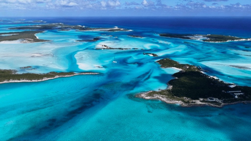
At the northeastern tip of the Dominican Republic, the Samaná peninsula is a land of its own. Here, geography imposes its own rhythm: a wide, protected bay, reliefs covered in rainforests, villages facing the sea. It’s not a destination designed for the accumulation of quick experiences, but a coherent space where nature, local life and tourism coexist without abrupt rupture.

A clearly defined territory

The Samaná peninsula juts out into the Atlantic, separated from the rest of the island by mountainous areas and roads that have long remained secondary. This relative isolation has helped preserve its character. The territory is organized around three main centers: Santa Bárbara de Samaná, the main port; Las Terrenas, more open to residential tourism; and Las Galeras, a more discreet coastal village at the eastern end. This configuration provides a rare legibility: each zone has its own function, without overshadowing the others. Visitors quickly understand how the peninsula is structured, and can move around without feeling saturated.

Samaná
@Godominicanrepublic
Samaná
@Godominicanrepublic

Samaná Bay, the heart of the sea

Samaná Bay is one of the central features of the region. Wide and relatively sheltered, it plays a major economic and ecological role. It is also one of the Caribbean’s best-known sites for seasonal sightings of humpback whales, which come here to breed between January and March. Beyond this aspect, the bay is the backdrop to daily life: fishing, shipping links, small ports and wharves set the pace for local activity. For travelers, it offers a visual and practical anchorage point, with open seascapes and a direct relationship between the city and the water.

Samaná
@Godominicanrepublic
Samaná
@Godominicanrepublic

Forests, rivers and waterfalls

The interior of the peninsula contrasts sharply with the coastline. The relief is covered with tropical rainforests, criss-crossed by rivers and trails. The El Limón waterfall, accessible from various routes, illustrates this natural wealth: a waterfall fed from the heights, amid dense vegetation. These spaces are a reminder that Samaná is not just a seaside destination. The peninsula retains a balance between inhabited areas, farmland and natural environments, which are still very much present just a few kilometers from the beaches.

Samaná
@Godominicanrepublic

Open, non-standardized beaches

The coastline offers a wide variety of beaches: long stretches lined with coconut palms, narrower coves, areas exposed to the Atlantic and quieter areas. In Las Terrenas, the beaches are easily accessible and integrated into local life. In Las Galeras, they become wilder, often far from the main roads. The absence of large, continuous built-up fronts helps to preserve a sense of space. The beaches remain predominantly public and are used by locals and visitors alike, contributing to a natural, uncluttered atmosphere.

Samaná
@Godominicanrepublic
Samaná
@Godominicanrepublic

Visible local life

Unlike some highly specialized Dominican tourist areas, Samaná leaves plenty of room for everyday life. Markets, local transport, artisanal fishing and village festivals are all part of the landscape. Tourism is present, sometimes sustained, but it does not erase local practices. This cohabitation gives the area a clear identity. Visitors are not isolated in an enclosed space: they share places, roads and beaches with a population that lives here all year round.

Samaná

Access and organization

Today, it is more accessible than ever before, thanks to renovated roads and the El Catey international airport, located on the western side of the peninsula. Transfers to the main tourist areas are by road, through agricultural and forested landscapes. The territory lends itself to both fixed stays and gradual discovery: a few days in Santa Bárbara de Samaná, followed by a trip to Las Terrenas or Las Galeras, will enable you to grasp the different facets of the peninsula.

Another view of the Dominican Republic

Putting Samaná in the spotlight means proposing a different reading of the Dominican Republic. Less urban than Santo Domingo, less standardized than some seaside resorts, the peninsula offers a territorial model based on continuity between nature, sea and villages. For travellers in search of a structured, legible Caribbean territory still deeply rooted in its landscapes, it is a solid destination. It doesn’t promise permanent exceptionalism, but a rare coherence that can be appreciated over time.

📸 ©Godominicanrepublic / Dominican Republic Tourism – Official Website

It lies in the north-east of the Dominican Republic, jutting out into the Atlantic and bordered by the bay of the same name.

The peninsula combines beaches, forests and active villages, with tourism that is present but not exclusive, leaving plenty of room for local life.

December to April is the busiest period, with a drier climate. From January to March, the bay is home to humpback whales.

In the Eastern Caribbean, St Kitts occupies a unique position. Main island of the state of St Kitts and NevisIt’s the only island to boast a large part of the region’s British colonial history, a remarkable built heritage and a volcanic geography that still shapes local life. Here, the territory is easy to read: a compact island, a central volcano, coastal villages and a capital facing the sea.

A founding island in Caribbean history

St Kitts is one of the first islands in the Eastern Caribbean to be colonized by the British in the XVIIᵉ century. It quickly became a strategic center for English colonial expansion in the region. This history can still be seen today in the organization of the territory, in the architecture and in the former sugar estates scattered across the island.

The capital, Basseterre, the city’s urban layout, with its structured streets, administrative buildings, churches and former port warehouses, is a legacy of this period. For visitors, the city offers a straightforward reading of Caribbean history, without excessive staging.

Saint-Christophe
Saint-Christophe

Brimstone Hill, a symbol of heritage

It’s impossible to mention St Kitts without mentioning Brimstone Hill Fortress a UNESCO World Heritage site. This monumental fortress, built by the British between the XVIIᵉ and XVIIIᵉ centuries, dominates the island’s northwest coast. It illustrates both European colonial rivalries and the island’s strategic importance in the Caribbean.

The remarkably well-preserved site provides an insight into the military organization of the period, and offers unobstructed views of the Caribbean Sea and the nearby island of Nieves. For visitors, Brimstone Hill is a major historical landmark.

Saint-Christophe
Saint-Christophe
Saint-Christophe

A structuring volcanic relief

The island’s landscape is dominated by Mount Liamuiga a volcano rising to an altitude of over 1,100 metres. Visible from most of the island, it influences climate, vegetation and human occupation. The fertile slopes have long been used for sugarcane cultivation, while the higher areas remain covered by tropical forests.

This relief gives the island a diversity of landscapes that is rare in such a small territory: coastal plains, green hills, volcanic craters and contrasting coastlines. For travelers, this variety means they can alternate between the sea, landscape observation and discovering the island’s interior.

Saint-Christophe
Saint-Christophe

A variety of beaches, from light sand to volcanic sand

The island’s coastline alternates between light sandy beaches and darker sandy beaches of volcanic origin. This diversity is a direct reflection of the island’s geology. Some beaches are developed and easily accessible, while others are more discreet, lined with vegetation and frequented mainly by locals.

The sea is generally calm on the Caribbean coast, making for pleasant swimming and supervised water sports. Most of the coastline remains open, with no systematic privatization, fostering a natural cohabitation between visitors and the local population.

Saint-Christophe
Saint-Christophe
North Friar's Beach
Saint-Christophe

An island focused on tourism, with no break with local life

St Kitts has been welcoming international visitors for several decades, notably via cruises and regional flights. This has led to the development of a solid tourism infrastructure: hotels, restaurants and transport services. However, tourism has not erased local life.

Villages, markets, cultural events and everyday practices remain visible and accessible. This continuity between tourist activity and island life gives the island a legible character, appreciated by travelers seeking a balance between comfort and territorial anchorage.

Saint-Christophe
Saint-Christophe
©My St. Kitts

A complete Caribbean destination

Highlighting this destination means presenting an island that combines several essential dimensions of the Caribbean:
– a central colonial history,
– an internationally recognized heritage,
– a structuring volcanic relief,
– a controlled opening up to tourism.

For visitors, the island offers a clear and coherent approach to the Caribbean territory. It shows how history, geography and tourism coexist in a small space, without obscuring local realities.

📸 ©My St. Kitts / Facebook page

It is located in the eastern Caribbean and, together with Niévès, forms an independent state to the southeast of Puerto Rico.

The island played a central role in the British colonization of the Caribbean and is home to Brimstone Hill, one of the region’s most important fortified sites.

Yes, the island has a well-developed tourist infrastructure, while retaining an active local life and a well-preserved heritage.

Tourism pressure on Caribbean heritage sites is no longer a marginal or one-off phenomenon. In many areas, the steady rise in visitor numbers, the increased vulnerability of ecosystems and local economic expectations are testing management models that have reached saturation point.

It is not so much the principles of World Heritage that are at stake, but rather the ability of territories to manage them over the long term. It was against this backdrop that UNESCO brought together World Heritage site managers from Latin America and the Caribbean in Santo Domingo. It was a discreet meeting, but one that revealed a shift in thinking: world heritage is now seen as a governance issue, rather than a lever for attractiveness.

Why is UNESCO intervening now?

For several years now, UNESCO has been observing a rapid evolution in uses around listed sites. In the Caribbean, this dynamic is particularly noticeable. Tourist flows are growing faster than the capacity to regulate them, while climate change is accentuating the fragility of natural environments and urban structures. This pressure is compounded by a still largely economic interpretation of heritage, which is often mobilized as a vector of visibility before being thought of as a common good to be preserved.

UNESCO ‘s intervention is part of a process of clarification. The aim is not to call the label into question, but to point out that classification entails lasting responsibilities. The meeting organized in Santo Domingo, from November 24 to 26, 2025, brought together management authorities and experts from nine countries in the region. Organized with the Ministry of Culture and the municipality of the National District, the workshop was part of the “Communities for Heritage – Latin America and the Caribbean” program, funded by the Ministry of Culture of the Kingdom of Saudi Arabia. Discussions focused on very concrete issues such as planning, monitoring flows, site governance and the ability of territories to arbitrate between visitor numbers, conservation and local uses.

UNESCO
UNESCO

UNESCO's "new lines": what's really changing?

Behind the discussions, a number of basic lines emerge.

  • – The first concerns the shift from a promotion approach to a management approach. The World Heritage is no longer seen as a tourist showcase, but as a space to be regulated.. Controlling traffic flows has become a central challenge, supported by tools for monitoring, assessing and anticipating visitor numbers.
  • – The second major change is the emphasis placed on local communities. UNESCO insists on their effective integration into site governance and economic spin-offs. Heritage cannot be sustainable if it is perceived as a resource captured from the outside, with no tangible benefit for the territories that bear it. This approach goes beyond the principle of inclusion to become a criterion for the credibility of management systems.
  • – Third structuring orientation: the operational integration of sustainability. Protecting ecosystems, adapting to climate change and managing tourism infrastructures are no longer declarations of intent. They are now part of concrete requirements, calling for clear, documented arbitration.

UNESCO also emphasizes local capacity-building, through training, heritage engineering and regional cooperation, in order to reduce the gaps between well-endowed sites and more fragile territories.

UNESCO
©UNESCO

What these lines mean for Caribbean territories

For sites that have already been classified, these guidelines translate into higher standards. Conservation can no longer be dissociated from tourism management, and management authorities are called upon to demonstrate their ability to reconcile visitor numbers, site protection and social acceptability.

The message is just as clear for territories applying for or registered on the tentative lists: future registrations will have to be based on sound management projects, integrating social, environmental and economic dimensions from the outset.

This development can be a real challenge. It highlights the complex trade-offs between immediate economic needs and long-term preservation, between tourist appeal and quality of life for local residents. But it also opens up the prospect of heritage tourism models that are better adapted to island realities, less dependent on growth in visitor numbers alone, and more based on the control of usage.

UNESCO
©UNESCO

Figures that reinforce the urgency

The data presented at the workshop underline the scale of the challenges. Tourism accounts for almost 10% of the gross domestic product of Latin America and the Caribbean and supports more than 35 million jobs in the region. However, this rapid growth is not without consequences: around 40% of World Heritage sites now report pressure from tourism.

In Santo Domingo, for example, the number of international visitors to the historic center in 2024 was 30% up on the previous year. This trend is a concrete illustration of the tensions faced by heritage site managers, who are called upon to maintain the balance between attractiveness, conservation and urban functioning.

UNESCO
©UNESCO

Towards a heritage conceived as a governance tool

The UNESCO-sponsored initiative also calls into question a tourism model that has long dominated the region. An over-exploited heritage, reduced to its image value, tends to be rapidly exhausted, to the detriment of the territories and their inhabitants. The guidelines discussed in Santo Domingo sketch out another path, that of a heritage conceived as a shared resource, to be managed and passed on rather than consumed.

The Santo Domingo meeting does not redefine world heritage; it redefines the responsibilities that go with it. For the Caribbean, these more demanding lines represent both a constraint and an opportunity.

They impose higher standards, but also offer a framework for reinforcing site governance, better controlling use and integrating heritage into sustainable territorial strategies. In the long term, World Heritage could thus become more than just a label of excellence in the Caribbean, but a veritable steering tool at the service of territories.

She observes a rapid intensification of tourist flows in the region, combined with increased vulnerability of ecosystems and historic centers. These developments are putting existing management models under strain. By reinforcing its guidelines, UNESCO seeks to remind us that World Heritage status implies lasting responsibilities in terms of governance, conservation and territorial balance.

It marks a clear shift from a promotional approach to a management approach. Controlling flows, integrating local communities and adapting to climate change become central criteria. Heritage is no longer seen simply as a lever for attractiveness, but as a space to be regulated and managed over the long term.

For sites already listed, these guidelines imply a higher level of requirement in terms of planning and governance. For candidate territories, they make future registrations conditional on the existence of solid, credible management projects. Ultimately, these guidelines may encourage tourism models that are better adapted to island realities and more respectful of local populations.

Tobago is often summed up in a few words: beaches, reefs, nature. Yet the island deserves more than a quick summary. Small in size but dense in what it has to offer, the island embodies a thoughtful Caribbean, where the territory has never yielded to excess. Here, tourism has developed without overshadowing local life, and nature remains a structuring framework.

Tobago
©Tobago
Tobago
Tobago

A separate island within Trinidad and Tobago

Situated in the south of the Caribbean arc, it has formed an independent state with Trinidad since 1962. Unlike its big industrial sister, the island has retained a resolutely insular profile. The island covers just over 300 km² and has a population of around 60,000. This small scale has a direct influence on the visitor experience: short distances, limited traffic, simple human relationships.

Scarborough, the capital, concentrates the administration and part of the commercial activity. Elsewhere, coastal villages and rural areas structure daily life. It’s not trying to compete with the big seaside destinations; it’s asserting a different logic, based on continuity and stability.

Tobago

Nature protected for centuries

One of Tobago’s strong points is its long-standing commitment to environmental protection. Buccoo Reef Marine Park officially created in the 1970s, is one of the oldest protected marine areas in the Caribbean. This shallow reef plays a central role in the coastal ecosystem and in the local economy, notably through artisanal fishing and supervised nautical activities.

Tobago
©Buccoo Reef Trust
©Buccoo Reef Trust

Inland, the Main Ridge Forest Reserve established in 1776, is often cited as the world’s oldest protected forest reserve. This forest covers a large part of the island’s backbone, helping to regulate the climate, preserve the soil and feed watercourses. For visitors, it offers a distinct counterpoint to the beaches: shady paths, gentle slopes, wildlife observation.

Tobago
©Stephen Kangal
Tobago
©Stephen Kangal
Tobago
©Stephen Kangal

Open, unstaged beaches

The island’s beaches are numerous and varied. Some, like Pigeon Point and Store Bay, are easily accessible and well developed. Others, on the east coast, are more exposed to the wind and less frequented. What they all have in common is the absence of massive beachfront constructions. Beaches remain public spaces, integrated into daily life.

This configuration attracts family tourism, independent travelers and visitors looking for extended stays. The island is not a quick stopover destination; it can be discovered over several days, sometimes weeks.

Tobago
©Tobago
Tobago

A culture rooted in continuity

The culture is the result of a long mixing of African heritage, British influences and Caribbean contributions. The English language structures the public space, but cultural practices remain profoundly local. Music, cuisine and community festivities are first conceived for the locals before being shared with visitors.

The Tobago Heritage Festival organized each year, illustrates this approach. It showcases villages, oral histories, dances and skills, without excessive staging. For the visitor, it’s an opportunity to observe a living culture, not a static one.

Tobago
Tobago
©Tobago
Tobago
Tobago Tourism Agency
Tobago
©Tobago heritage Festival

Controlled tourism

Accommodation on the island is deliberately modest. There are medium-sized hotels, guest houses and independent rentals. Large resorts are rare and concentrated in specific areas. This strategy limits pressure on infrastructure and natural resources.

Local authorities, including the Tobago House of Assembly. The local authorities play a central role in regional planning. Decisions relating to tourism, the environment and transport are often taken on an island-wide basis, which reinforces the coherence of the choices made.

A clear destination for travellers

Tobago is accessible by regional and international flights via A.N.R. Robinson International Airport. Entry formalities are straightforward for many travelers, and the island has sufficient infrastructure for a comfortable stay without excess.

For tourists, it represents a well-balanced destination: beaches, nature, culture and services are all present, without permanent competition between these elements. The island doesn’t seek to surprise, but to last.

Tobago
©Tobago

Highlighting the island today means underlining that another trajectory is possible in the Caribbean. That of an island that has chosen protection, moderation and continuity. It’s not spectacular for its accumulation, but for the coherence of its model.

For travelers with an eye for how a territory develops, the island offers a rare example: an island that welcomes visitors without transforming itself excessively.

Tobago lies to the south of the Caribbean arc. Together with Trinidad, it forms the independent state of Trinidad and Tobago, off the coast of Venezuela.

Tobago is characterized by deliberately limited tourism, strong protection of its reefs and forests, and local life that is still very much alive.

Yes, the island offers a stable environment, sufficient infrastructure and a pace of life conducive to stays of several weeks, without excessive tourist pressure.

In Martinique, attracting tourists is no longer just about beaches, landscapes and cultural heritage. It’s also built behind the scenes: on the productive sectors, local know-how and infrastructures that make coherent development possible. As part of Touristriel Week, Richès Karayib took a look at a little-explored dynamic: the opening up of industrial sites as a lever for attractiveness, providing a concrete illustration of how the region really works.

On a regional scale, this dynamic is part of the AMPI (Association Martiniquaise pour la Promotion de l’Industrie). Through its member companies, including BATIMAT Recyclage, it deploys a coherent cycle combining the structuring of sectors, the opening up of industrial sites and the transmission of know-how.

The touristriel: understanding before consuming

The word touristriel takes on its full meaning here. It refers to an experience of understanding the region, based on openness, pedagogy and a clear understanding of know-how. Visiting an industrial site means taking a fresh look at the flows, materials, constraints, technical and environmental choices that shape the area.

touristriel
touristriel
touristriel
touristriel

For Charles Larcher, President of AMPI, the stakes are clear:

“Opening our factories means that Martiniquans and visitors alike can discover their industry, meet its employees and understand local know-how. Industry is a heritage, part of the soul of a territory.”

Touristriel doesn’t add another offering: it enriches the existing offer by bringing coherence between sustainable tourism discourse and productive reality.

Charles Larcher

BATIMAT Recycling: open to explain, not to seduce

In the field, BATIMAT Recyclage is a perfect illustration of this approach. Specializing in the recycling of inert construction waste, the company transforms rubble, concrete and deconstruction materials into reusable resources, as part of a circular economy approach.

For Yannis Bride: Quality, Health, Safety and Environment Manager, the opening of the site is not part of a tourism strategy in the strict sense of the term:

“We open our doors because we have nothing to hide. Showing our processes, explaining how we manage waste, how we limit our impacts, it’s a way of making our action understandable and visible.”

This transparency arouses curiosity among schoolchildren, elected representatives, professionals and visitors alike. A curiosity focused on understanding waste flows and the structural choices that determine an island’s sustainability.

touristriel

Territorial appeal: credibility before image

The link between industry and tourism is not based on staging, but on credibility. credibility. A region that welcomes visitors while outsourcing the management of its waste, materials or resources loses coherence. Conversely, a well-structured local industry boosts confidence and the overall image of the destination.

On the scale of Martinique, this logic goes far beyond the construction sector alone. Agri-food, energy, construction, recycling: these are just some of the areas in which openness and pedagogy can play a key role. indirect levers of attractiveness by showing that the region produces, transforms and innovates.

touristriel
touristriel

A Caribbean dynamic yet to be structured

Discussions during Tourist Week also highlighted a broader issue: Caribbean cooperation.
While the challenges are common – waste management, limited resources, environmental constraints – responses are often fragmented, hampered by standards, regulations and the absence of a shared strategy.

For both AMPI and BATIMAT Recyclage, the opening of sites can also become a starting point for starting point for regional professional exchanges. This is another area where the touristriel is an eye-opener. Here again, touristriel acts as an eye-opener, creating spaces for dialogue where previously there were only silos.

touristriel
touristriel

Show to welcome

The touristriel reveals industry as a living, visible component of the region. In this way, it is helping to change the way people look at Martinique. By opening their doors, players like BATIMAT Recyclage, supported by the vision conveyed by AMPI, are contributing to a more mature attractiveness, based on understanding, consistency and responsibility. An attractiveness that not only seduces, but also reassuring, credible and inspiring.

In a Caribbean in search of sustainable models adapted to its island realities, this approach could well become one of the markers of a more conscious tourism – and of a more assertive territorial development.

FAQ

Touristriel is an approach that combines tourism and industry, opening up productive sites to help visitors understand the know-how, constraints and choices that structure Martinique’s territory.

Touristriel enhances attractiveness by bringing coherence between sustainable development rhetoric and production reality. It enhances a region’s credibility before its image, by showing how it produces, recycles and innovates locally.

No. The touristriel is also aimed at Martiniquans, schoolchildren, elected representatives and professionals. It fosters a collective understanding of how the region works, and paves the way for local and Caribbean cooperation.

Off the Caribbean coast of Nicaragua, Little Corn Island is an island in a class of its own. Big Corn Island’s little sister, it stands out for its simplicity: no roads, no cars, no big complexes. The island can be explored on foot, to the rhythm of the tides, conversations and the wind. This chosen slowness shapes a rare experience in the contemporary Caribbean.

An island with no roads, no cars, no rush

Little Corn Island measures a mere three square kilometers. It can only be reached by boat from Big Corn Island, itself linked to the Nicaraguan mainland by plane from Managua or Bluefields. Once disembarked, the scene is set: sandy paths, coconut tree-lined lanes, wooden houses and natural beaches just a few minutes’ walk away.

The absence of motorized traffic is not a marketing argument, but a daily reality. People get around on foot, sometimes using wheelbarrows to transport goods. This simple organization immediately transforms the relationship with the place: time slows down, space tightens up, attention is focused on the essential.

Little Corn Island

An English-speaking and Afro-Caribbean Caribbean

Contrary to the predominantly Spanish-speaking image of Nicaragua, Little Corn Island belongs fully to the English-speaking Caribbean.

The most widely used language is Creole English, a direct legacy of the region’s Afro-Caribbean history.

The local culture is closer to that of the British Isles of the Caribbean than to that of the Nicaraguan Pacific.

Music, cuisine and everyday practices reflect this identity.

Grilled fish, coconut rice, seafood and simple dishes are the order of the day.

Exchanges with local people are direct, often punctuated by tales of fishing, the seasons and changes in the sea.

Little Corn Island
Little Corn Island

Natural beaches and accessible reefs

The coastline of Little Corn Island alternates between light sandy beaches, volcanic rocks and areas of reef close to the shore. Some beaches, particularly on the north and east coasts, remain uncrowded and untouched. The water is generally calm, with good visibility for underwater observation from the beach.

The coral reefs surrounding the island are part of the Western Caribbean Sea ecosystem. They are home to tropical fish, sea turtles and coral formations that can be seen without a boat. This proximity to the marine environment is one of the great assets of Little Corn Island provided you adopt respectful practices.

Little Corn Island
Little Corn Island

Small-scale tourism

Little Corn Island offers neither large hotels nor massive infrastructures. Accommodation is based on small inns, ecological lodges and guest houses. This deliberately limited offer preserves the balance of the island and encourages a direct local economy.

Visitors come here to relax, walk, swim, read and socialize. Activities are organized around the sea, nature and free time. The island attracts travellers who appreciate unspoilt environments and a discreet form of tourism, far removed from the logic of over-consumption.

Little Corn Island
Little Corn Island

A visible and active island community

With a small population, Little Corn Island functions like an extended village. Inhabitants know each other, children play on the paths, fishermen return at sunrise or sunset. Local life is not hidden behind tourist infrastructures: it’s at the heart of the experience.

This proximity creates a special atmosphere. Visitors are not spectators, but are invited to respect a collective rhythm, to observe and adapt. The island imposes a form of restraint that quickly becomes a sought-after quality.

Little Corn Island
Little Corn Island

An essential Caribbean

Highlight Little Corn Island is a reminder that the Caribbean isn’t just about big seaside resorts. It’s also a mosaic of modest islands, Afro-descendant cultures and territories that have chosen sobriety over expansion.

The island does not promise abundance, but balance. It offers a direct relationship with the sea, the people and time. For travelers in search of a sincere, human and comprehensible Caribbean, Little Corn Island is a destination in a class of its own, where people come first and foremost to slow down.

Little Corn Island

Photo credits

Little Corn Island, Nicaragua – Official Facebook

FAQ

Little Corn Island lies off the Caribbean coast of Nicaragua. It is part of the Corn Islands, close to Big Corn Island in the Caribbean Sea.

Big Corn Island is reached by air from Managua, followed by a 30-minute boat trip to Little Corn Island.

No. Little Corn Island favors small-scale tourism, without roads or big resorts, focusing on nature, walking and local life.

Cayo Santa María is located to the north of Cuba, in the Jardines del Rey archipelago. A small island renowned for its luminous beaches and peaceful atmosphere, it attracts visitors in search of calm seas, fine sand and a holiday designed for relaxation. Connected to the mainland by a long dike road, it offers a unique experience: that of a modern island territory, yet still very close to nature.

An island linked to the mainland by a spectacular road

Access to Cayo Santa María is via the Pedraplénan almost 48 km linking the town of Caibarién to all the cayos in the region.

The crossing passes over lagoons, shallow waters and mangrove swamps.

From this point on, the journey becomes a parenthesis: wide horizons, sea breezes and the impression of moving towards an unspoilt island world.

The island is part of the province of Villa Clara alongside Cayo Las Brujas and Cayo Ensenachos.

This area has been developed to accommodate structured seaside tourism, while maintaining a clear separation between natural areas and hotel zones.

Cayo Santa Maria

Beaches and calm seas, at the heart of the experience

The north coast of Cayo Santa María is home to some of the archipelago’s most sought-after beaches. The sand is particularly clear, the water fresh and regular, and the seabed remains shallow for several dozen meters.


Areas such as Playa Perla Blanca, Playa Las Gaviotas or the main beach of Santa María are often cited as some of the most pleasant on the island.

Conditions are ideal for leisurely swims, long walks along the water’s edge and relaxing moments with family or couple.

The wilder southern coastline features mangroves, salt marshes and protected wetlands.

This balance between developed beaches and discreet nature contributes greatly to the island’s charm.

Cayo Santa Maria
Cayo Santa Maria
Cayo Santa Maria

A destination designed for travelers' comfort

Since 2000, Cayo Santa María has developed into one of the leading seaside resorts in northern Cuba. There are many all-inclusive hotels here, each offering services tailored to families, couples or groups, with direct access to the beach, swimming pools, varied catering and entertainment.

However, the atmosphere remains measured: the island has no cities, only hotel zones. Staff come daily from the nearby towns of Caibarién, Remedios and Camajuaní.

Cayo Santa Maria

Between nature and tranquillity

Even if it is landscaped, Cayo Santa María retains a strong natural presence. Mangroves are home to seabirds, dunes protect the coastline, and some areas are included in regional environmental programs.
The landscape is a reminder that the sea and coastal ecosystems are the true masters of the place, and that developments have been designed to respect the island’s fragile morphology.

Cayo Santa Maria
Cayo Santa Maria

Access and useful information for travellers

The main point of entry is the Abel Santamaría International Airport of Santa Clara (SNU). Transfers from the airport to the island take about 90 minutes to 2 hours depending on traffic conditions and stops.

For international travellers, Cuba requests :

  • – a valid passport ;
  • – a tourist card (visa) ;
  • – recognized medical insurance.

These formalities are easy to obtain via an agency, the airline or consular services.

Cayo Santa Maria
Cayo Santa Maria

An island to rest and breathe

Cayo Santa María is perfect for visitors looking for a gentle atmosphere, safe beaches and the possibility of staying for several days without pressure or schedules. The calm sea, the light of the Cuban coastline and the simplicity of the setting make it an ideal destination for family trips, beach breaks or slow-paced vacations.

FAQ

Cayo Santa María is located in northern Cuba, in the Jardines del Rey archipelago, and is part of the Villa Clara province.

The island can be reached via Santa Clara airport, then the Pedrapléna 48 km road-dike linking the mainland to the archipelago.

No. Cayo Santa María has no permanent population: only hotels and tourist services are located here.

On Saturday, December 6, 2025, aboard the MSC Virtuosa docked in Fort-de-France, MSC Cruises officially launched its 2025-2026 season in the West Indies. The event, which brought together the company’s strategic partners, clarified the group’s ambitions for the region, with a major announcement: the arrival of a second ship for the 2026-2027 winter season.

Beyond the numbers and the ships, MSC Crociere and the French West Indies are writing a story of ties, trust and territory.

Benoit Chareyre

Focus on the MSC Virtuosa "floating palace" of the seas

The MSC Virtuosa, due to enter service in 2021, is one of the flagships of the MSC Cruises fleet. 331 mm longmetres, 43 metres widemetres and 181541 metric tons, she can accommodate up to 6334 passengers in 2421 cabins: a size that gives her the status of a “megapaceliner“status worldwide.

MSC

On board, the ship blends luxury, comfort and entertainment to offer a complete experience:

  • – A spectacular interior promenade (the Galleria Virtuosa) covered by an LED dome – the lively heart of the ship, with stores, bars, restaurants and night-time entertainment.
  • – A range of equipment for every profileA wide range of facilities: swimming pools, spa & wellness, theater, wellness area, relaxation areas, cabins in several categories (interior, sea view, balcony, suites, families…), suitable for couples, families or groups.
  • – Modern comfort designed for long-distance travelAccommodation, catering, entertainment, on-board service… the Virtuosa functions like a small “floating village.
MSC
MSC
MSC
MSC
MSC
MSC

But beyond luxury, the Virtuosa appears to be a player of opportunity for stopover regions.With its large number of passengers, regular port calls and wide range of accommodation, the cruise ship is a potentially important vector of economic, tourist and cultural spin-offs for destinations like Martinique. Each port of call becomes a key moment, and her welcome to Martinique confirms the island’s growing status on the world cruise map.

MSC
MSC
MSC
MSC
MSC
MSC

MSC Cruises: strategic focus on the West Indies

For Benoit Chareyre, Sales Director France for MSC Croisières, the Caribbean market is key to the group’s strategy: “Fort-de-France is the second largest French embarkation port after Marseille. It’s a fundamental anchorage for us”.

With cruise penetration reaching 10% in Martinique and Guadeloupe, compared with 4% in mainland France, the region is confirming its potential. To meet this growing demand, in 2026 MSC will deploy a second ship operating year-round between Fort-de-France and La Romana (Dominican Republic).

“MSC loves Martinique, loves the West Indies. […] Why not hope that 90% of Martinicans will embark at least once in Fort-de-France to discover the cruise”, he adds.

MSC also intends to strengthen connections with mainland France, by facilitating access to the West Indies via airline partnerships. But the stakes are also local: excursions, transfers, craftsmen, guides…

“Every port of call is an economic opportunity for local professionals. We want cruises to be an opportunity to discover the destination,” emphasizes Benoît Chareyre.

Tangible benefits for the region

Every stopover is more than just a tourist visit: it activates an entire value chain. Between transport, guides, excursions, catering, crafts and port logistics, a whole economic fabric is consolidated. Professionals can approach port agents to propose activities, tours and even local products as part of the cruise experience.

It’s also a lever for employment: each landing generates operational needs in terms of security, entertainment, maintenance and reception.

“Excursions are often booked in advance, which guarantees business visibility for service providers,” explains Benoit Chareyre.

A local dynamic rooted in trust

Bruno Mencé, Director of the Grand Port de la Martinique, delivered an emotional speech full of gratitude:

“This morning, as I passed my office, I saw the boat in the harbor… it gave me extraordinary joy. I told myself that life is starting all over again.”

He recalled the long-standing and solid partnership between MSC and the port, the fruit of long-standing technical and human efforts:

“MSC and the port have a great history. A story based on trust and mutual enrichment.

Highlighting the gradual build-up of infrastructures and ports of call, he praised the mobilization of all local players around the cruise industry:

“You have all the players in front of you who are on the ball. We’re a team dedicated to providing you and your customers with the best possible service.”

He adds with ambition and humour: “Our goal is to overtake Marseille.

An island to promote, an impact to make better known

Bénédicte Di Geronimo, President of the Comité Martiniquais du Tourisme, underlined the strength of the link between Martinique and MSC Cruises:

“It’s a real pleasure for us, every time, to see these big ships here. […] The history between Martinique and MSC is an old one. A story, I think, of the heart.”

She emphasized the destination’s assets:

“A technicality, a certain level of welcome that makes the arrival of these big boats safe, but also an extraordinary island, thanks to which excursions can intensify a voyage in such a beautiful boat.”

But beyond the emotion, she invited a broader reading of the fallout:

“The impact of cruising isn’t just the purchases you make on a stroll through Fort-de-France. It’s much more far-reaching, involving far more activities than that.”

Finally, she called for collective ownership of this dynamic:

“We need to have this discourse with our population, so that this cruise development takes place in an atmosphere of calm, understanding and support, I hope.”

An assertive regional positioning

MSC Cruises’ strategy is not limited to adding new rotations. By positioning Fort-de-France as its annual home port, the company is sending out a clear signal: the French Caribbean is no longer just an exotic stopover, but a first-rate logistical and commercial base. This ambition also implies a strengthening of local infrastructures and skills.

Fort-de-France is consolidating its role as a benchmark port in the Caribbean, within a fast-developing regional network. The prospect of overtaking Marseille in the next few years, often repeated in the tone of a challenge, embodies this turning point.

Towards more integrated, sustainable cruising?

Behind the growth prospects, the MSC team is emphasizing a responsible development strategy, with recent ships, mostly built in France, and long-term planning up to 2032. Local roots, both economic and cultural, are at the heart of the roadmap. West Indian craftsmen and professionals are invited to get in touch with port agents to propose offers adapted to excursions: “There are real opportunities for local players to seize,” insists Benoit Chareyre.

A shared ambition for the Caribbean

Thanks to the growing number of departures and calls, Fort-de-France is consolidating its central role in the cruise appeal of the West Indies. The arrival of a second ship in 2026 testifies to MSC’s determination to anchor its business in the region over the long term. The challenge is to offer an experience that benefits both passengers and the region. This ambition is shared by all the players on board the Virtuosa – port authorities, institutions, tourism operators and logistics partners such as Antilles Shipping – who know that cruising in the Caribbean can become an engine for sustainable transformation.

FAQ

MSC Cruises sees the French West Indies as a strategic market, with a cruise penetration rate well above that of mainland France. Fort-de-France has become France’s second-largest port of embarkation after Marseille, prompting the company to deploy more capacity there. The arrival of a second ship in the 2026-2027 season meets growing demand and confirms the importance of the region to the company’s development.

Each port of call activates a complete value chain: transport, excursions, catering, crafts, guides, security, port services, logistics… As excursions are often booked in advance, they offer valuable visibility to local service providers. In addition to purchases in the city center, the impact extends to numerous professions linked to hospitality, mobility and tourism activities.

The big news is the arrival of a second ship in 2026, operating year-round between Fort-de-France and La Romana. MSC also wants to facilitate access from mainland France through air partnerships, strengthen local excursions and integrate more local products into the cruise experience. The company is thus betting on a sustainable presence, more connected to the economic and cultural players in the West Indies.

When approaching Guanaja from the sea, the island’s first impression is of its silhouette: pine-covered hills, encircled by a ring of reefs and small cays. Nothing flashy, just a landscape that immediately makes one thing clear: here, the sea, the mountains and the villages still live on a human scale.

A mountainous island facing the sea

Guanaja
Guanaja
Guanaja

Guanaja is one of the three large Bay Islands off the coast of Honduras. It lies some 70 km from the mainland, and offers a surprising relief for an island of its size. Often nicknamed “the Green IslandGuanaja is largely covered by Caribbean pine forests and tropical vegetation. From the ridges, a string of coves, discreet beaches and reefs form a natural boundary between the island and the open sea.

The forests were severely damaged by Hurricane Mitch in 1998, but some of the vegetation cover is gradually recovering. The island’s interior remains largely undeveloped, with trails used by locals and fishermen.

Guanaja
Guanaja
Guanaja

Bonacca, a town set on the sea

The contrast is striking when you arrive at Bonacca – often referred to as The Cay. Most of Guanaja’s inhabitants live on this tiny islet built on the water. The tightly-packed wooden houses rest on stilts, linked by footbridges and narrow lanes. Together, they form a singular urban network, where you walk above the sea and boats circulate as if in a labyrinth.

Bonacca is sometimes compared to a small Caribbean Venice, not for its aesthetics, but for the way it organizes a town around the sea. Several thousand inhabitants live on less than 40 hectares, with shops, schools, churches and docks in constant motion. The place is not a tourist attraction: it’s a concrete response to the constraints of a limited island territory.

Guanaja

A major reef in the Mesoamerican Barrier Reef

Around the island, the sea is a structuring element. The island is bordered by the Mesoamerican Barrier Reef, the second largest reef system in the world. The surrounding clear waters, seagrass beds, coral reefs and wetlands are part of the Bay Islands National Marine Park.

This park, created to preserve an essential marine heritage, covers hundreds of thousands of hectares and includes Roatán, Utila and Guanaja. On site, associations such as BICA work with local residents to protect the reefs, regulate fishing and involve local communities. These efforts enable the island to maintain a balanced relationship between human activity and the preservation of its marine environment.

Guanaja
Guanaja

A Caribbean history that links cocoa, pine trees and sea routes

The history of Guanaja far exceeds its size. In 1502, Christopher Columbus landed here on his fourth voyage and named it Isla de los Pinos, in reference to the forests that already covered it. Accounts of the time tell us that it was here that he first encountered cocoa, transported by merchants in large pirogues.

Later, the island became a transit point for privateers, merchants and families from the Cayman Islands, which explains the coexistence of English and Spanish in daily life today. Guanaja went through several names – Caguamara, Isla de Pinos, Bonacca – before being officially renamed as it is today.

Living on Guanaja: fishing, resilience and community ties

Guanaja
Guanaja

The island’s economy is still based on fishing and limited tourism, focused on nature and the sea. Hurricane Mitch left a lasting impression on the island’s inhabitants, destroying many homes, particularly in Bonacca. But the island proved resilient. The inhabitants rebuilt, slowly and with their own means, taking into account the sea and the constraints of the territory.

The local culture blends Honduran traditions, Anglo-Caribbean influences and specific festive practices such as the Junkanoo, where locals parade in costumes made from recycled fabrics and materials. These celebrations, often modest and very communal, are a reminder of the strength of the social bond that characterizes the island.

Guanaja
Guanaja

A discreet and essential Caribbean

To showcase Guanaja is to tell the story of a different Caribbean: an island that refuses the race to outdo itself, that relies on sobriety, the sea and the forest rather than on large-scale development. An island where we still build on the water because land is scarce, where we protect the reefs because they are the first line of defence, where we live as close as nature will allow.

Guanaja is a discreet island, but essential to understanding Caribbean diversity. An island where the sea structures life, where history can be read in the reefs and stilts, and where community remains the primary force.

📷©Guanaja, Islas de la Bahia / Facebook

FAQ

Guanaja is part of the Bay Islands archipelago off the north coast of Honduras. The island can be reached by boat or plane from Roatán and La Ceiba.

Bonacca, the inhabited heart of Guanaja, was built on a very small islet to avoid coastal mosquitoes and benefit from better ventilation. The houses on stilts are an extension of this adaptation.

Yes, the island belongs to Bay Islands National Marine Park which protects reefs, seagrass beds and mangroves around Guanaja, Roatán and Utila.

Holbox is one of those places that gives the impression of having remained away from the hustle and bustle of the world. A small strip of land in the north of the Yucatán peninsula, it lives to the rhythm of its sandy streets, its extensive mangroves, its shallow sea and the colors that change every hour of the day. This is not an island that seeks to make an impression, but one that asserts itself through its assumed tranquility.

A timeless island, accessible but unspoilt

To reach Holbox, you have to reach Chiquilá, then cross a narrow strait by ferry. As soon as you arrive, you’ll notice that there are no cars here. You can get around by golf cart, bicycle or on foot. The soil remains sandy, as if the island had decided not to be tamed. This simplicity creates a special atmosphere: no horns, no traffic, just the sound of the wind, the murmur of the sea and the conversations that rise from the village’s wooden terraces. The island doesn’t offer a break, but a different way of inhabiting a place.

The island of Holbox

Landscapes that rest the gaze

Holbox’s main beach stretches for kilometers without a break, facing a sea that always seems calm. The water, shallow for several dozen meters, offers a turquoise cameo that slips into softer hues as you move further away from the shore.

Further afield, the mangroves create a world of their own: intertwined roots, birds poised, reflections almost motionless. Flamingos, sometimes present between April and October, add an unexpected touch to these landscapes. The island also bears the memory of the Yum Balam reserve, a protected area covering more than 150,000 hectares and a reminder that nature is the first inhabitant here.

The island of Holbox

A village that tells the story of an island

The village of Holbox has a real visual unity: colorful facades, murals, small family addresses, fruit stands, wooden terraces, hand-painted signs. Every street reveals a detail: a sleeping cat, a fisherman mending his net, a child crossing with a kite. Street art plays an important role here. Created by local artists or invited to festivals, the frescoes tell of the sea, animals and Mexican mythologies. They are a reminder that the island has chosen gentleness rather than excess, expression rather than performance.

The island of Holbox

The sea, a discreet but essential companion

In Holbox, the sea is omnipresent. It accompanies walkers in the morning, turns pink at sunset, and carries the boats of the fishermen who leave at dawn. The locals still make their living from local fishing, respecting the seasons and protected areas.

The island is also known for its calm waters, ideal for kayaking, paddle-boarding or simply contemplating. At times, the sea seems so shallow that you might think it’s wavering between a body of water and a mirror of light.

The island of Holbox

A territory that moves forward with care

Holbox is no longer a secret, but the island is trying to preserve what makes it unique. Inhabitants and local players encourage respectful practices: gentle travel, respect for mangroves, reduction of plastic, support for small family structures.

The Yum Balam reserve sets clear limits to prevent the island from losing its soul. This slow, careful approach is in keeping with the spirit of the island: welcoming, yes, but without denaturing itself.

L'île de Holbox
L'île de Holbox

Holbox, an island on a human scale

At a time when many Caribbean destinations are growing fast, the island remains a place that prefers measure to excess. Accommodations remain close to the ground, streets have no aggressive angles, and the sky retains all the space it deserves.

Highlighting Holbox means choosing to tell the story of an island that has managed to preserve a rare balance: beauty without excess, simplicity without harshness, authenticity without folklore. An island that invites you to walk softly, to look differently and to let time take its rightful place.

Photo credits

Isla Holbox – Official Facebook